Reverse geocoding converts GPS coordinates (latitude and longitude) into readable location data like addresses, postal codes, or landmarks. For example, coordinates like 51.952659, 7.632473 can be translated into "Friedrich-Ebert-Straße 7, 48153 Münster, Germany." This process is key for applications like delivery tracking, navigation, and emergency response systems, especially in regions like Germany, where detailed geospatial data is available.
Key Points:
- How it works: Matches coordinates to geospatial databases (e.g., OpenStreetMap) to return location details.
- Outputs: Includes addresses, postal codes, administrative regions, and sometimes time zones or landmarks.
- Use cases: Essential for ride-sharing, fleet management, logistics, and compliance with regional address formats (e.g., German postal code conventions).
- Tools: APIs like Zip2Geo make implementation simple, offering scalable plans for different needs.
Reverse geocoding helps turn raw GPS data into practical, localized information for user-friendly applications.
How to do Reverse Geocoding with the OpenCage API - Python Tutorial
How Reverse Geocoding Works
How Reverse Geocoding Works: From Coordinates to Address
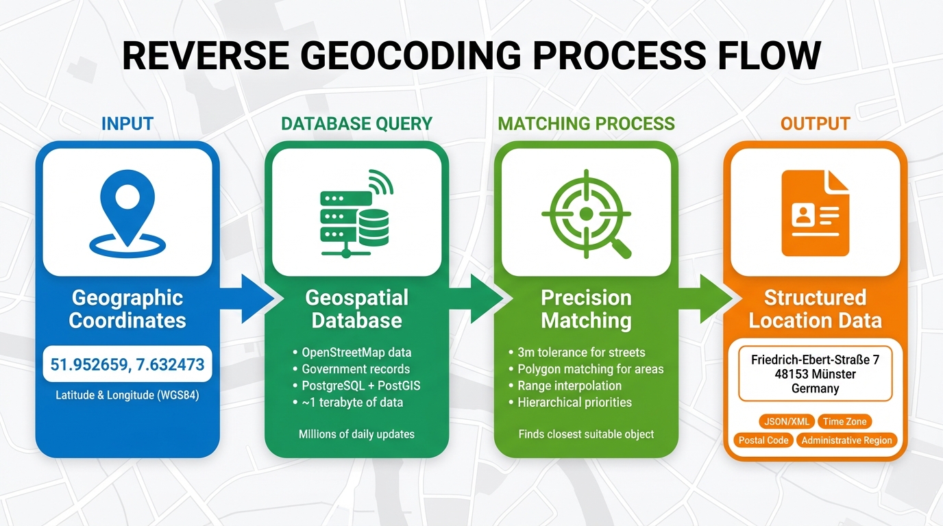
Reverse geocoding transforms geographic coordinates into understandable location data by systematically matching those coordinates with geographic objects. The process begins when latitude and longitude values - typically in the WGS84 projection - are sent to a geospatial database. The system then identifies the closest geographic entity, which could be a specific point (like a building), a linear feature (such as a road), or a broader area (like a city boundary).
To ensure precision, the system uses a combination of hierarchical priorities and distance tolerances. For instance, strict tolerances, such as 3 metres for street-level addresses, help achieve accurate results. If rooftop-level data isn't available, range interpolation is used to estimate an address between two known road points. As noted in Nominatim's documentation:
The reverse geocoding API does not exactly compute the address for the coordinate it receives. It works by finding the closest suitable OSM object and returning its address information.
This process begins with clear data inputs and delivers detailed location outputs.
Data Inputs and Outputs
The input for reverse geocoding is simple: geographic coordinates in the form of latitude and longitude. For example, a pair like 51.952659, 7.632473 serves as the starting point.
The output, however, is comprehensive. It includes structured details (typically in JSON or XML format) such as street numbers, road names, localities, administrative regions, postal codes, and countries. Many modern reverse geocoding systems go further, adding annotations like time zones, local currency, sunrise/sunset times, and dialling codes. The formatted address string is tailored to local conventions. In Germany, for instance, the postal code (PLZ) is placed before the city name, ensuring the output feels natural to users. This detailed information lays the groundwork for precise matches in geospatial databases.
Geospatial Databases and Matching
To deliver accurate results, reverse geocoding systems rely heavily on extensive geospatial databases. These systems combine data from various sources, including open-source platforms like OpenStreetMap (OSM), proprietary datasets, government records, and public domain resources. PostgreSQL with PostGIS is often used to handle the complex spatial queries required for this process.
The matching process involves applying specific tolerances to confirm a match. For example, large geographic features like parks, universities, or city districts are stored as polygons. If coordinates fall within one of these boundaries, the system returns the area feature instead of a distant street address. OpenStreetMap alone holds nearly a terabyte of data, with millions of daily updates from contributors. This ongoing maintenance ensures that reverse geocoding results stay accurate, even as the physical world changes.
Common Outputs of Reverse Geocoding
Standard Data Types
When you input coordinates into a reverse geocoding system, the response typically includes a structured array of location details. This data often comes in formats like JSON, GeoJSON, or XML, organized into objects containing an address or address_components array.
The most common outputs include full addresses, house numbers, street names, postal codes (PLZ), neighbourhoods, cities, administrative regions (Bundesländer), and country information. Some systems also provide additional details such as points of interest, time zones (e.g., Europe/Berlin), or Plus Codes - location references accurate to within 10 metres of the specified point. For example, a response might prioritize landmarks like the "Brandenburg Gate" or specific business names over standard street addresses when relevant.
This hierarchical structure allows users to choose the level of detail they need. For broader tasks, like mapping or analytics, you might only need the Bundesland. For precise tasks, such as last-mile delivery, you’ll require exact house numbers and street names.
Applications for German-Speaking Regions
Reverse geocoding systems often adapt their outputs to align with regional needs, enhancing their usability in German-speaking areas. For instance, postal codes (PLZ), paired with locality names, are essential for efficient mail sorting, delivery routing, and logistics.
Administrative boundaries are equally critical for tasks like tax compliance and payment processing. The administrative_area_level_1 field, which represents Bundesländer (e.g., Bayern or Nordrhein-Westfalen), is particularly useful for calculating state-specific taxes or adhering to local regulations. In cities, district names such as "Wilhelmsburg" or "Innenstadtring" add vital context for location-based services.
When dealing with city-states like Berlin, Hamburg, or Bremen, avoid redundant listings such as "Berlin, Berlin." While technically accurate, this repetition feels awkward and non-local. As OpenCage explains:
"'Berlin, Berlin' is technically correct in some theoretical sense, but stylistically it is wrong. It's the type of little detail that makes a digital service feel clunky and non-local".
For a polished result, configure your system to display the name just once.
In Austria, the PostalLoc format is widely used. This combines the postal code and city name into a single string, like "7132 Frauenkirchen", which is both practical and familiar to local users. In multilingual regions like Switzerland or Belgium, specifying the language parameter (e.g., de) ensures that place names appear in German rather than French or Italian. This is especially important for driver navigation and customer communication.
sbb-itb-823d7e3
When to Use Reverse Geocoding
Location-Based Applications
Reverse geocoding transforms raw coordinates into readable addresses. Imagine opening a ride-sharing app and seeing "51.9606649, 7.6261347" - not very helpful, right? Instead, you’d expect to see "Friedrich-Ebert-Straße 7, 48153 Münster". This conversion makes location-based services far easier to use and understand.
But it’s not just about displaying addresses. Reverse geocoding can pull out administrative details like districts (e.g., "Innenstadtring") or states (e.g., North Rhine-Westphalia). This helps local search services organise results by area. It also determines time zones automatically - like "Europe/Berlin" - which is essential for accurate scheduling, arrival estimates, and invoicing in logistics and travel apps.
For industries like finance or delivery operating across Germany, reverse geocoding ensures uniformity in location data. By standardising coordinates into consistent address formats, it simplifies backend systems, regardless of the device or GPS sensor used to capture the original data.
Delivery and Logistics
Reverse geocoding is indispensable in delivery and logistics, where precision and efficiency are key.
Fleet managers rely on readable addresses to make quick decisions. Converting coordinates into addresses like "Friedrich-Ebert-Straße, Münster" enables real-time vehicle tracking and helps teams adjust to delays or reroute deliveries efficiently.
The last mile - the final stretch of a delivery - is where accuracy matters most. "Rooftop" precision ensures drivers reach the exact building entrance, not just the general area. This is especially critical in dense urban areas where multiple buildings can share similar addresses. In industrial zones or remote areas where regular addresses might be unclear, Plus Codes provide an alternative, pinpointing locations with accuracy within 10 metres.
By converting coordinates into detailed, reliable addresses, reverse geocoding helps streamline fleet management, cut down on delivery mistakes, and maintain accurate backend records. It even identifies time zones and administrative regions, automating timestamps for travel logs and ensuring proper tax invoicing for regional operations.
Navigation and Compliance
Reverse geocoding also plays a vital role in navigation and regulatory compliance.
Navigation systems use reverse geocoding to provide human-friendly directions. While machines handle latitude and longitude, people need street names, landmarks, and area references to navigate effectively. In emergencies, this becomes even more critical. German emergency services, for instance, require precise street addresses, house numbers, and postal codes to dispatch responders quickly and accurately.
For businesses in regulated industries, reverse geocoding helps meet compliance standards. Financial services can apply region biasing (e.g., setting the region parameter to "de") to ensure addresses adhere to German formatting and legal requirements. High-precision "Rooftop" data is also crucial for identifying whether a coordinate lies within restricted zones, private properties, or specific administrative areas - important for applications that need to respect boundaries or enforce access controls.
Implementing Reverse Geocoding with Zip2Geo
Getting Started with Zip2Geo
To get started with reverse geocoding using Zip2Geo, begin by registering on their platform, creating a project, and generating your API key. You can further secure your API key by restricting its usage to specific IPs or referrers.
Zip2Geo provides four pricing plans, all billed in euros, making it especially convenient for developers in Europe:
| Plan | Monthly Price | Annual Price | Requests/Month | Best For |
|---|---|---|---|---|
| Free | €0 | €0 | 200 | Testing and small personal projects |
| Starter | €5 | €50 | 2,000 | Simple live projects and side apps |
| Pro | €19 | €190 | 20,000 | Growing apps and teams (includes SLA) |
| Scale | €49 | €490 | 100,000 | High-traffic products and enterprise needs |
The Free plan requires no credit card and grants access to all endpoints, making it perfect for testing before committing to a paid plan. Higher-tier plans come with added benefits like priority support, SLA guarantees, and dedicated communication channels.
Once you’ve set up your API key, the next step is learning how to make API requests to fetch precise location details.
Making API Requests
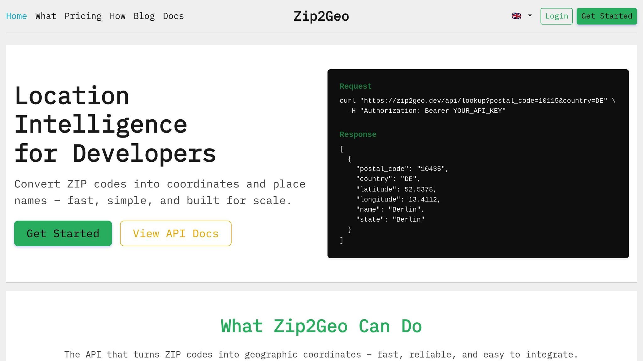
To retrieve location data, use your API key to send HTTP GET requests to Zip2Geo. The main parameters you'll need are latitude and longitude. For instance, providing coordinates such as 51.9606649, 7.6261347 will return a JSON response with detailed address components, including house number, road, suburb, city, state, and postcode.
JSON is the default format, ensuring easy parsing and integration into your application. You can also use optional parameters like type and language to refine your results. For example, adding lang=de will return the output in German.
To ensure smooth operation, implement error handling by monitoring status codes such as "OK", "ZERO_RESULTS", and "OVER_QUERY_LIMIT". This allows your application to manage edge cases and quota limits effectively.
For applications requiring high-volume processing, Zip2Geo offers a batch processing feature.
Batch Processing and Scalability
Zip2Geo's batch processing feature allows you to bundle up to 1,000 queries into a single POST request, potentially cutting API call costs by up to 50%. To further optimize efficiency, use parameters like types or result_type to filter data - such as focusing on "postcode" or "address" - ensuring the API only processes the information you need.
If you encounter a "429 Too Many Requests" error, you can implement an exponential backoff strategy to handle rate limits without disrupting your application’s functionality.
Zip2Geo is particularly accurate in the DACH region (Germany, Austria, Switzerland), thanks to its comprehensive data coverage and reliance on government-verified datasets. This makes it a reliable choice for applications that demand precise street-level geocoding in German-speaking areas.
Conclusion
Reverse geocoding transforms raw GPS coordinates into understandable location details - like street addresses, postal codes, cities, or landmarks - making it easier to provide clear geographic context for users. This process is invaluable whether you're building a delivery platform that requires accurate pickup points, a navigation app to help users orient themselves, or a logistics system that needs standardized tracking data. Simply put, reverse geocoding turns complex GPS data into something practical and user-friendly.
But it doesn't stop at basic conversions. Reverse geocoding adds extra layers of information, such as time zones or postal codes, which can improve business operations and decision-making. For German-speaking regions, localized results ensure a seamless and professional user experience, further enhancing customer satisfaction.
Zip2Geo makes reverse geocoding straightforward with its easy-to-use API and flexible pricing. It even offers a free plan that includes 200 requests per month - no credit card required. Whether you're working on live applications or batch processing, Zip2Geo scales reliably to meet your needs.
From improving user interfaces to optimizing delivery routes or unifying location data, reverse geocoding delivers the geographic insights that modern apps rely on. Get started with Zip2Geo today and take your location data to the next level.
FAQs
How does reverse geocoding make navigation systems more user-friendly?
Reverse geocoding takes geographic coordinates - like latitude and longitude - and converts them into readable addresses or recognizable place names. This process helps navigation systems deliver clearer directions, identify nearby landmarks, and generate routes that are easier for people to follow.
By providing detailed location information, reverse geocoding improves the precision and practicality of navigation tools, making them more helpful for activities such as delivery scheduling, daily travel, or discovering unfamiliar places.
How does reverse geocoding benefit logistics operations?
Reverse geocoding is the process of translating geographic coordinates (latitude and longitude) into clear, human-readable addresses, such as street names, postal codes, and cities. For logistics companies, this means raw GPS data can be turned into precise delivery points that drivers and customers can easily identify.
By adding context to location data, reverse geocoding helps validate routes, minimise delivery mistakes, and match shipments to the correct address hierarchy (like street, city, or postal code). It also enables dynamic route adjustments, more accurate ETA predictions, and adherence to regional delivery schedules. On top of that, it improves the user experience by offering clear location details, empowering dispatchers to make better decisions, and ensuring customers receive timely and reliable updates.
This technology plays a key role in boosting operational efficiency - whether it's standardising location records, fine-tuning inventory placement, or optimising delivery hubs. The result? Businesses save time, cut costs, and avoid unnecessary errors.
How does reverse geocoding support compliance in Germany?
Reverse geocoding is crucial for ensuring compliance with local regulations in Germany by transforming geographic coordinates into clear, human-readable addresses. This process is especially important for meeting GDPR standards, as it supports the responsible management of location data while safeguarding user privacy. Additionally, it ensures adherence to German address formatting conventions and postal code requirements.
Accurate and dependable address data provided through reverse geocoding helps businesses fulfill legal responsibilities, streamline operations, and build trust with users - particularly when expanding services within Germany or throughout the EU.