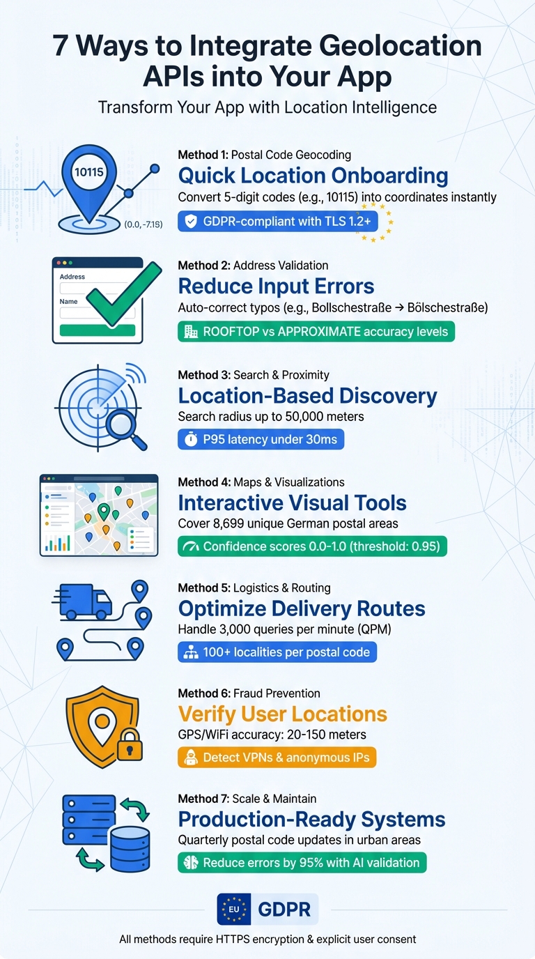
Geolocation APIs can transform your app by enabling it to access and use location data effectively. From improving address accuracy to fraud prevention, these APIs offer practical solutions while ensuring compliance with strict EU privacy standards like GDPR. Here’s a quick overview of how you can use them:
- Postal Code Geocoding: Simplify user onboarding by converting postal codes into coordinates and administrative details.
- Address Validation: Fix input errors and verify address data for real-time or bulk processing.
- Search and Proximity Features: Enable location-based searches and refine results with filters.
- Maps and Visualisations: Use postal code data to create interactive maps and insights.
- Logistics and Routing: Optimize delivery routes and service areas with precise geocoding.
- Fraud Prevention: Cross-check user-provided locations with real-time data to detect inconsistencies.
- Scaling Systems: Maintain up-to-date geolocation data and handle high query volumes efficiently.
7 Ways to Integrate Geolocation APIs: Complete Implementation Guide
Geolocation Web API Tutorial | Personalize Visitor Experience With HTML5 & IP
sbb-itb-823d7e3
1. Use Postal Code Geocoding for Quick Location Onboarding
Postal code geocoding simplifies the onboarding process by turning a simple five-digit entry, like 10115 for Berlin Mitte, into precise coordinates and administrative information. This autocomplete feature not only speeds up data entry but also minimizes errors and fills out registration forms almost instantly. It's a crucial first step before diving into the more technical details outlined later.
Germany’s postal code system, known as PLZ, uses five digits to quickly identify regions. The first digit represents a broad area, making it easier for APIs to pinpoint locations and enhance data with missing details like federal states or delivery districts. This efficient structure is particularly useful for streamlining location-based services.
For real-time onboarding, the Place Autocomplete service is ideal for handling partial inputs with low latency. On the other hand, the Geocoding API works better for processing complete addresses.
Prioritize GDPR Compliance
When selecting a geocoding provider, ensure they comply with GDPR regulations. Look for providers that explicitly state GDPR adherence and offer Data Processing Agreements (DPAs). To safeguard user data, all API requests should use HTTPS with at least TLS Version 1.2. As Sheharyar Malik, a Software Engineer at IPGeolocation, emphasizes:
Following GDPR isn't just a duty, it's a fundamental part of who we are.
Optimize Accuracy and Performance
Use component filtering, such as country:DE, to restrict API results to Germany. This improves accuracy while ensuring that data processing stays relevant to the region. Performance optimization is equally important. Cache validated addresses for a short period (e.g., one week) to reduce redundant API calls and cut costs. Additionally, implement client-side logic to confirm that postal codes follow Germany’s five-digit format before making API requests. This simple step avoids unnecessary queries.
For cost-effective solutions, services like Zip2Geo offer scalable pricing. Their plans range from a free tier with 200 requests per month to enterprise options with 100,000 requests per month for €49. These options cater to projects of all sizes while maintaining lightning-fast response times.
2. Validate Addresses and Reduce Input Errors
Address validation plays a key role in fixing input errors and ensuring data accuracy, whether you're handling real-time user entries or processing bulk data. For real-time scenarios, tools like Place Autocomplete can help, while the Geocoding API is better suited for bulk address processing. Choosing the right endpoint depends on your specific needs. For the most detailed results, the Address Validation API provides highly specific feedback - for instance, it can verify if a particular flat number exists within a building. Additionally, precise response flags and parameter filtering can significantly improve validation accuracy.
Here’s a practical example: when given the input "Bollschestraße 86, 12587, DE" (missing the city and with a typo in the street name), the Address Validation API corrected it to "Bölschestraße 86, 12587 Berlin, DE" and verified it at the PREMISE level. In contrast, the standard Geocoding API returned ZERO_RESULTS. This level of correction is especially critical for German addresses, which often include special characters like ä, ö, ü, and ß, requiring proper URL encoding to process correctly.
Pay attention to the partial_match flag in API responses. If this flag is true, it means the geocoder couldn’t find an exact match - likely due to a typo or an invalid street number. Also, check the location_type parameter: ROOFTOP indicates precise, street-level accuracy, while APPROXIMATE reflects a broader, less accurate result. To refine results further, apply country filtering (e.g., country: 'DE') to improve precision and adhere to local data regulations.
Consider adding a map marker to let users visually confirm the address. To avoid overloading the service, implement exponential backoff strategies (e.g., delays of 100 ms, 200 ms, 400 ms). Always use HTTPS to protect user data and restrict results to specific countries (e.g., country: 'DE') to enhance accuracy and comply with GDPR requirements.
3. Add Search, Filtering, and Proximity Features
To enable location-based discovery, start by converting postal codes into geographic coordinates using a Geocoding API. This step helps center a search radius and makes proximity searches possible. For real-time user inputs, integrate Place Autocomplete to handle incomplete or misspelled postal codes efficiently, ensuring low response times.
Once you have the coordinates, you can perform proximity searches using a Nearby Search function. For instance, the Google Places API supports search radii of up to 50,000 meters. You can refine the results further by applying filters - such as business type, price range (using parameters like "minprice" and "maxprice"), or operational status (e.g., "opennow"). To enhance sorting accuracy, use a Distance Matrix API to calculate travel times or road distances.
When working with high-performance APIs, aim for P95 latency under 30 milliseconds. Avoid scheduling synchronized requests at fixed intervals (e.g., at the start of each minute), as this can cause traffic spikes up to 60 times the normal level [25,40]. Instead, randomize request timings and use exponential backoff for handling failed requests, starting with delays of around 100 milliseconds. These strategies help maintain both performance and cost efficiency while improving regional accuracy.
To further fine-tune results, specify region and language parameters in your API requests. This ensures postal code formats match local standards - for example, German postal codes follow a five-digit format like "10115" for Berlin. Always use HTTPS for API requests involving user data to comply with GDPR. Additionally, convert addresses to Place IDs to reduce latency and optimize costs by requesting detailed place information only when a user selects a specific result, rather than pre-fetching data for all nearby locations.
For large-scale operations, take advantage of bulk processing, which can handle up to 100 postal codes per request. If your application requires global coverage, look for services supporting over 121 countries and more than 3.5 million postal codes. These features ensure scalability and efficiency for both localized and worldwide applications.
4. Build Maps and Visualisations with Postal Code Data
Transforming postal codes into map coordinates opens the door to creating interactive visual tools. Germany’s postal code system, known as Postleitzahl (PLZ), uses 5-digit codes covering 8,699 unique areas, from 01067 (Dresden) to 99998 (Körner and Weinbergen). With this data, you can develop maps that present real-time insights tied to postal code regions.
To ensure accurate mapping, pay close attention to API precision indicators. For instance, Google Maps includes a location_type field where ROOFTOP represents an exact address, while APPROXIMATE or GEOMETRIC_CENTER indicates less precise central points of postal code areas. Geoapify, on the other hand, provides a numerical confidence score between 0.0 and 1.0. Setting a threshold, such as 0.95, can help you filter out less reliable results. These techniques, combined with refined geolocation data, ensure your maps are both precise and compliant with standards.
When designing interactive visualisations, consider using choropleth maps with dynamic colour schemes to highlight trends like delivery density or service coverage across different postal code areas. Adding zoom and pan options can make it easier for users to explore data, from a regional overview down to specific towns. To focus exclusively on Germany, use API parameters like country:DE or filter=countrycode:de.
Before mapping, validate German postal codes with the regular expression /\d{5}/g. For applications that demand high performance and response times under 30 milliseconds, consider using self-hosted location databases to reduce reliance on external API calls.
5. Improve Logistics, Routing, and Service Areas by Postal Code
Postal code geocoding plays a crucial role in streamlining delivery operations by converting Germany’s 5-digit postal codes into precise latitude and longitude coordinates. For example, converting the postal code 10115 (Berlin Mitte) into exact coordinates enables routing systems to calculate the shortest paths between multiple delivery points, cutting down travel time. The API includes a location_type field to indicate the accuracy of the geocoding: ROOFTOP offers pinpoint precision for specific addresses, while GEOMETRIC_CENTER represents the central point of a postal code area. For last-mile deliveries, prioritize ROOFTOP data to ensure accuracy, and flag APPROXIMATE results for manual verification to avoid unnecessary delays. This level of precision not only improves routing but also helps define service areas efficiently.
In Germany, postal codes often encompass multiple towns or neighbourhoods, which can complicate service area planning. To address this, the API provides a postcode_localities array listing all locations covered by a single postal code - sometimes up to 100 localities. This feature helps logistics teams identify all the areas they need to serve under a single code. To ensure the data remains specific to Germany, use the country: DE filter when making requests.
Handling a high volume of geocoding queries efficiently is key to maintaining smooth logistics operations. The service allows up to 3,000 queries per minute (QPM) across both client-side and server-side calls. To manage this limit, implement an exponential backoff strategy for failed requests - start with a 100-millisecond delay and double it with each retry. This approach effectively handles temporary 4XX or 5XX errors without overwhelming the network. Additionally, randomize the timing of bulk geocoding tasks to prevent sudden spikes in requests.
For faster route calculations, convert addresses into Place IDs beforehand. This eliminates the need for repeated geocoding during routing, significantly reducing latency. To further optimize, cache the latitude and longitude values of postal codes, but only store the specific data your routing system requires. Avoid saving entire JSON responses to comply with data minimization practices.
Lastly, set the language parameter to de to ensure that formatted addresses are returned in German. This makes delivery instructions easier for local drivers to understand and follow, enhancing overall efficiency.
6. Prevent Fraud and Meet Compliance Requirements with Geolocation
Geolocation data plays a key role in verifying user locations, helping to prevent fraud and meet compliance standards in Germany and the EU. By cross-referencing a user-provided address with real-time device coordinates, apps can identify discrepancies, such as attempts to create fake accounts. To ensure accuracy, a proximity threshold of about 150 metres is suggested to account for potential GPS variability. On mobile devices, obtaining ACCESS_FINE_LOCATION permissions allows for precise location tracking, often accurate to within one metre. These steps align seamlessly with broader geolocation strategies previously discussed.
For precise location verification, GPS and WiFi data are the most reliable, offering accuracy within 20–150 metres. In contrast, cell tower and IP-based data are far less accurate, with larger error ranges. GPS and WiFi data are particularly effective for fraud prevention because IP-based methods can be easily circumvented using VPNs or proxies. To enhance security further, specialised APIs can identify anonymous IP addresses and detect VPN usage. This level of precision complements earlier strategies for user onboarding and address validation.
As noted by MagicEndpoint, identity verification increasingly requires confirming that logins and authentications originate from expected physical locations.
Building on fraud prevention, advanced analytics tools add another layer of security. Real-time anomaly detection systems can flag suspicious activities, such as "impossible" travel scenarios (e.g., a user appearing in Berlin at 14:00 and Munich at 14:15). AI-powered systems now monitor transaction patterns on a large scale, enabling quicker detection of irregularities while reducing the need for constant manual reviews.
Additionally, GDPR regulations in Germany and across the EU require explicit user consent before accessing location data. To comply, all API requests must use HTTPS, and data minimisation practices should allow users to delete their geolocation data upon request. These measures ensure both security and adherence to privacy standards.
7. Scale and Maintain Postal Code Geolocation in Production
Scaling geolocation systems for postal codes, especially in dynamic regions like Germany and the EU, requires constant monitoring and precise strategies to keep operations smooth and data accurate.
In Germany, postal codes can change quarterly in rapidly growing urban areas. To keep up, production systems must automatically sync with reliable digital platforms to ensure data stays up-to-date. Using trusted sources like Germany's Bundesamt für Kartographie und Geodäsie helps maintain high accuracy in reference data. Additionally, AI-powered validation tools have proven to reduce shipping and geocoding errors by up to 95%, while robust operational processes can lower overall shipping errors by 20%.
Performance Optimization
To handle scaling effectively, implement caching strategies such as storing only Place IDs and apply rate limiting to manage API usage efficiently. Use exponential backoff techniques - starting with a 100 ms delay and doubling it for retries - to handle failed requests. Avoid scheduling bulk API requests at fixed times; instead, spread them out using randomized timing. These measures, combined with earlier integration practices, help ensure the system can handle increased loads without compromising performance.
Error Handling and Localization
Effective error management is essential. Monitor key status codes and introduce brief retry delays when issues arise. To localize results effectively, use ISO 3166-1 alpha-2 codes (e.g., "DE" for Germany) to filter data by country. This ensures adherence to German address formatting conventions, such as placing the house number after the street name and ensuring the 5-digit postal code (PLZ) appears before the city name. These steps not only improve accuracy but also align with earlier recommendations for maintaining local data integrity.
Compliance and Security
Adhering to GDPR is a non-negotiable aspect of production systems. All API requests should use HTTPS to secure user data and API keys during transmission. Implement data minimization practices and ensure explicit user consent is obtained before accessing location data. While caching metadata tied to user IDs can help identify invalid data, storing corrected addresses should only be done transparently, such as during checkout processes where users are informed and give their consent.
Handling Regional Variations
For German and EU postal codes, ensure your system supports the 5-digit format, where the first digit represents the zone. To tackle input variations, use fuzzy matching algorithms capable of handling spelling differences and phonetic similarities. Assign confidence scores to flag ambiguous entries, allowing for human review when necessary. These techniques not only enhance accuracy but also accommodate the diverse ways users input data, reinforcing the system's reliability across regions.
Conclusion
Geolocation APIs can significantly improve user experience, streamline processes, and ensure better compliance. By leveraging postal code geocoding, businesses can minimise manual errors, speed up onboarding processes, and enable location-based features. Features like multi-level confidence scoring help validate addresses and highlight uncertainties, reducing the risk of delivery issues.
When implementing geolocation solutions, it’s crucial to cater to regional requirements. For developers in Germany and throughout the EU, selecting a service that meets local demands is essential. Zip2Geo stands out as a specialised postal code geocoding service tailored for German and European markets. It also offers global coverage across more than 100 countries. With RESTful API endpoints, JSON responses, and lightning-fast response times suitable for real-time applications, it ensures seamless integration. Flexible pricing, including a free tier of 200 requests per month, makes it accessible for testing and scaling to production.
To ensure reliability, focus on robust error handling, HTTPS security, and GDPR-compliant data practices. Structured parameters and country-specific filters can improve search accuracy. Additionally, implementing exponential backoff and randomised API calls can help maintain system stability during high demand.
FAQs
How can I make sure my app complies with GDPR when using geolocation APIs?
To comply with GDPR when using geolocation APIs, it’s important to recognize that location data qualifies as personal data and is often sensitive. This means you must secure explicit user consent by clearly explaining what data you’re collecting, why you need it, and how long it will be stored. Consent must be active - like an opt-in checkbox - and users should have the option to withdraw it at any time.
Some essential steps to follow include offering a clear and transparent privacy policy in German, limiting data collection to what’s absolutely necessary for your app’s functionality, and ensuring secure data transmission and storage through methods like encryption and HTTPS. If you’re transferring data to countries outside the EU, you’ll need to comply with GDPR requirements by relying on EU adequacy decisions, standard contractual clauses, or equivalent safeguards.
It’s also crucial to document your data processing activities and, for high-risk applications such as those involving continuous tracking, conduct a Data Protection Impact Assessment (DPIA). Partnering with a GDPR-compliant API provider not only helps meet these legal requirements but also strengthens trust among German users.
How can I improve the performance of geolocation APIs in my app?
To get the best performance out of a geolocation API in your app, it's crucial to prioritize both security and efficiency. Always use HTTPS for requests to ensure a secure connection, and protect those requests with an API key for authentication. When sending data, keep it lean - only include what’s absolutely necessary, like relevant cellTowers or wifiAccessPoints. To further optimize, enable compression methods like gzip to shrink payload sizes.
Another smart move is to implement caching for frequently requested locations, especially for devices that don’t change position often. Trigger API calls only when they’re truly needed, such as during user interactions, instead of relying on fixed intervals for updates. This approach not only conserves resources but also helps cut down costs.
Keep a close eye on your API usage by monitoring requests, setting daily quotas, and enabling budget alerts. These steps ensure you won’t be caught off guard by unexpected expenses. By combining these techniques, you can improve your app’s performance, provide a smoother user experience, and manage costs effectively.
How do geolocation APIs enhance fraud prevention in apps?
Geolocation APIs play a key role in strengthening fraud prevention by pinpointing the real-time location of an IP address and cross-referencing it with user-provided details. By identifying data like the country, region, city, postal code, and even approximate latitude and longitude, businesses can quickly flag transactions that originate from unexpected or potentially high-risk locations. For instance, a sudden shift in location - especially to areas known for higher fraud rates - can trigger automated alerts, helping companies act swiftly.
These services also offer additional insights, such as the internet service provider (ISP), the organisation behind the connection, and whether the user is operating through a proxy or hosting network. Spotting proxy use or IP ranges commonly associated with fraudulent behaviour allows businesses to block suspicious activities or require extra verification steps. When combined with other risk indicators, like unusual buying habits, geolocation tools become part of a powerful, multi-layered security system. This approach not only enhances fraud detection but also helps reduce the chances of flagging legitimate transactions incorrectly.