Geocoding transforms addresses like postal codes into geographic coordinates, enabling location-based services such as route planning, proximity searches, and market analysis. This process converts human-readable data into structured formats for mapping and analysis. Businesses use geocoding to optimize logistics, select retail locations, and improve marketing strategies. For instance, tools like the Zip2Geo API provide precise geographic data for German postal codes, supporting tasks like delivery route optimization and customer segmentation.
Key Takeaways:
- Geocoding converts addresses into coordinates, while reverse geocoding translates coordinates back into readable addresses.
- Applications include logistics, retail planning, and hyper-local marketing.
- Tools like Zip2Geo simplify geocoding with features tailored for Germany, offering precise data for postal codes, cities, and states.
- Integration tips: Use caching to reduce API costs, handle errors like partial matches, and localize for German address formats.
Geocoding ensures businesses can make data-driven decisions based on accurate location data, improving efficiency and customer experiences.
How Geocoding Works: From Address to Actionable Intelligence
Introduction to HERE Geocoding and Search
sbb-itb-823d7e3
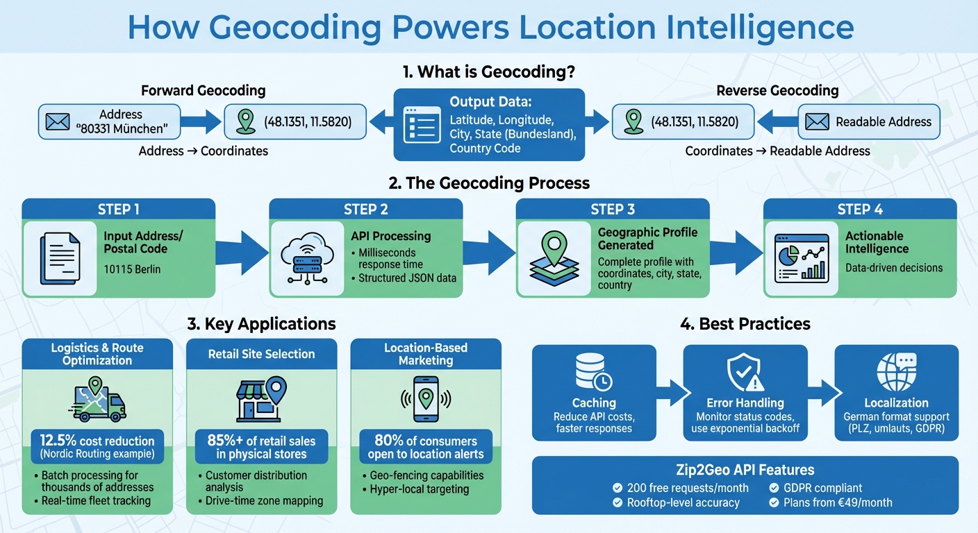
How Geocoding Powers Location Intelligence
Geocoding acts as the bridge between human-readable addresses and data that computers can process. For example, converting a postal code like "80331 München" into coordinates (48.1351, 11.5820) transforms unstructured text into structured data that can be analysed, compared, and visualised. This transformation is essential for location intelligence. Without it, applications wouldn’t be able to calculate distances, identify patterns, or make decisions based on spatial data. By turning postal codes into detailed geographic profiles, geocoding enables businesses to extract insights and take action.
One of geocoding’s key strengths is its consistency. While postal boundaries may change due to administrative updates or urban expansion, geographic coordinates remain fixed. This reliability ensures that data remains accurate for long-term use, whether you’re tracking customer locations over time or planning infrastructure projects.
Converting ZIP Codes into Geographic Data
When a geocoding service processes a German postal code, it provides much more than just latitude and longitude. The output often includes a complete geographic profile: city names, states (Bundesländer), and sometimes even districts or municipalities. This structured data allows applications to perform advanced spatial analysis.
Modern geocoding services can achieve "rooftop" accuracy, pinpointing the exact centre of a building rather than just a general area. This level of precision is critical for logistics companies navigating to specific loading docks or for retailers analysing foot traffic around potential store locations. Such granular data helps businesses refine their strategies and make more informed decisions.
Using Geodata for Better Decisions
Structured geographic data opens the door to smarter decision-making across various industries. For instance, retail chains can use geocoded data to select store locations based on population density, income levels, and traffic patterns. This approach helps identify customer clusters and market opportunities, replacing guesswork with clear, visualised insights.
A great example is The Weather Company, which uses geocoding to deliver over 20 billion daily forecasts worldwide. By leveraging reverse geocoding to pinpoint user locations, they provide hyper-local weather updates instead of broad regional forecasts. This turns a general service into a highly personalised tool, trusted for real-time decision-making.
Logistics and supply chain operations also thrive on geocoded data. Precise location information enables businesses to optimise delivery routes, schedule pickups more effectively, and strategically position inventory. These efficiencies reduce fuel consumption, cut down delays, and improve overall operational performance.
Using the Zip2Geo API for Geocoding
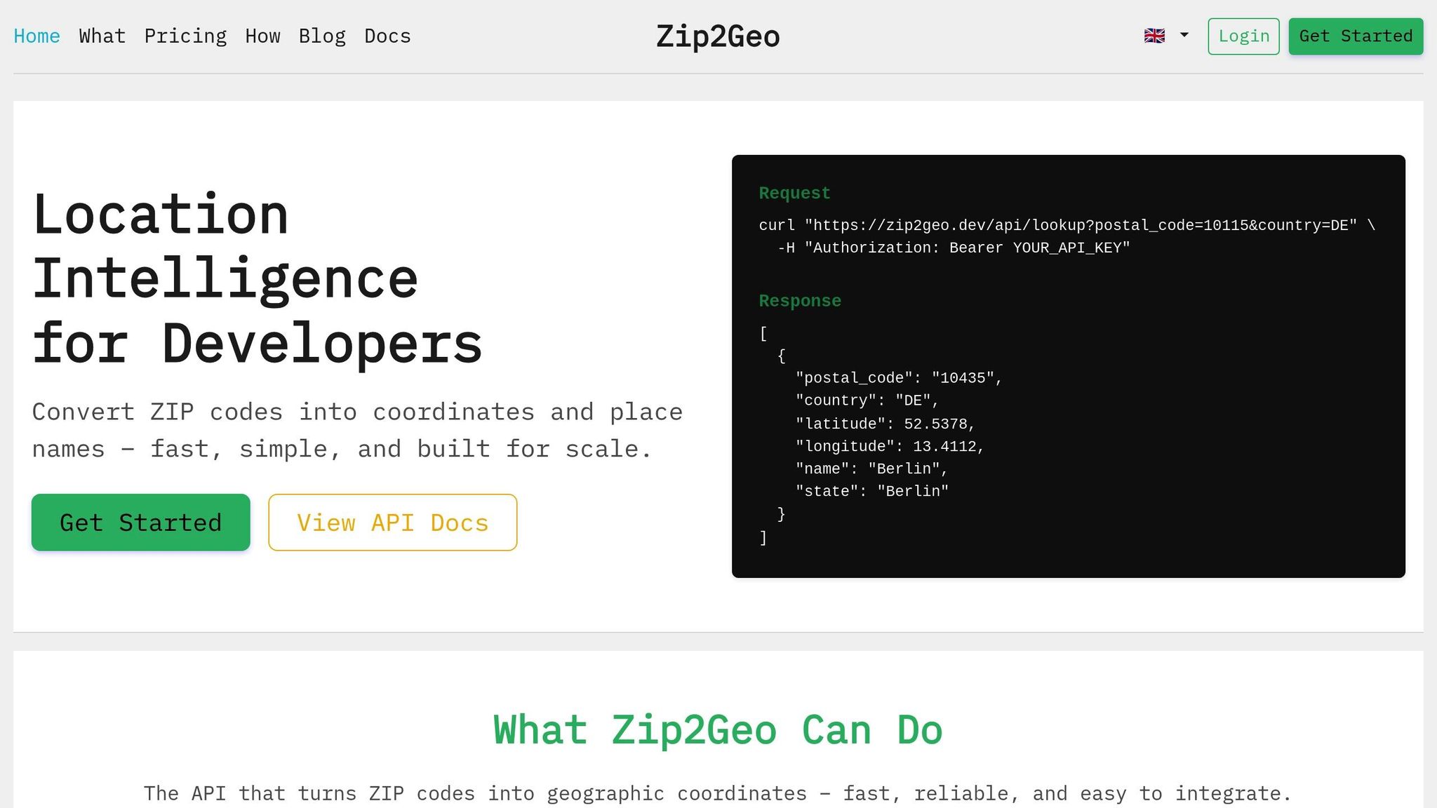
Integrating an API effectively can turn geocoded data into practical insights, especially when it comes to location-based applications. The Zip2Geo API is a RESTful service designed to convert postal codes into geographic coordinates and place names. It supports a variety of global postal code formats and delivers structured JSON data that's easy to parse and incorporate into your systems.
Key Features of Zip2Geo
Zip2Geo offers rapid responses, delivering complete geographic profiles - including latitude, longitude, city, state, and country - within milliseconds. This makes it suitable for live applications as well as batch processing tasks. Its RESTful design ensures compatibility with standard HTTP GET requests, making it accessible across popular programming languages like JavaScript, Python, or Java.
The API also includes an interactive testing feature, allowing you to validate response structures before coding. This hands-on approach saves time during implementation and reduces the chances of errors. For applications targeting Germany, Zip2Geo provides specialised support for five-digit PLZ formats and localised city names, ensuring accuracy and relevance.
Getting Started with Zip2Geo
To begin, register for an API key, configure your HTTP client with the base URL and credentials, and test the service using sample German postal codes like 10115 (Berlin) or 80331 (Munich). The Free plan offers 200 requests per month without requiring a credit card, making it perfect for initial testing. For security, store your API key in environment variables and apply restrictions based on IP or referrer headers. Once set up, you can process JSON responses to extract geodata for your application.
Working with API Responses
After successful integration, the API provides detailed JSON responses that are straightforward to use. Each response includes fields like latitude, longitude, city, state (or Bundesland for German addresses), and country_code (formatted as ISO 3166-1 alpha-2). This structured data can be directly utilized for location-based intelligence.
To handle errors, use try-catch blocks for managing 4xx or 5xx HTTP response codes. If you encounter rate limits (HTTP 429), leverage the "Retry-After" header to implement exponential backoff strategies. For large datasets, caching frequently requested coordinates locally can help reduce API costs and improve response speeds, ensuring smoother performance for your application.
Practical Applications of Geocoding
Geocoding takes raw location data and turns it into actionable tools that can reshape logistics, retail planning, and marketing strategies.
Logistics and Route Optimization
In Germany, delivery services rely on geocoding to convert postal codes and addresses - like those in Düsseldorf or Hamburg - into precise geographic coordinates. This eliminates guesswork in route planning and ensures that drivers can locate the correct entrances without hassle.
Batch geocoding is a game-changer for logistics companies, enabling them to process thousands of delivery addresses in one go. This is crucial for daily fleet operations. Tools like Zip2Geo’s batch geocoding allow businesses to pre-process entire delivery databases, reducing delays and providing real-time updates. Nordic Routing, for example, cut operational costs by 12.5% by using geocoding for address validation and route optimization.
Reverse geocoding plays an equally important role. It translates GPS coordinates from delivery vehicles back into readable German addresses, allowing dispatchers to monitor fleet locations in real time. Whether a driver is on Friedrichstraße in Berlin or approaching a warehouse in Stuttgart, this system ensures seamless tracking. Together, forward and reverse geocoding create a robust location intelligence framework that improves delivery accuracy and reduces failed deliveries caused by outdated or incorrect address data.
These logistical benefits naturally extend into retail planning.
Retail Site Selection and Market Analysis
Retailers leverage geocoding to pinpoint the best locations for new stores by analysing customer distribution and the proximity of competitors. By converting postal codes into coordinates, businesses can create accurate drive- or walking-time zones that consider local obstacles like cross-streets or public transport routes.
When scouting potential sites, developers can geocode existing store and competitor locations to identify underserved areas. For example, a study in Auckland analysing 117 million data points found that mobile behavioural data often revealed customer patterns that differed significantly from traditional catchment assumptions. This level of insight is crucial, especially since over 85% of retail sales in the United States still take place in physical stores. Precise geocoding ensures that retailers choose locations primed for success.
But geocoding doesn’t just stop at site selection - it also powers highly targeted marketing efforts.
Location-Based Marketing
Geocoding allows marketers to reach customers with pinpoint accuracy. Businesses can create geo-fencing zones around specific areas - like shopping districts, transit hubs, or event venues - to send targeted messages when a user’s device enters that zone.
For German companies, tools like Zip2Geo enable segmentation by city, Bundesland, or proximity to landmarks. This can be especially effective, as research shows that 80% of consumers are open to receiving location-based alerts from businesses. For instance, a retailer in Berlin could send promotional offers to customers within a 5-kilometre radius of their store. Similarly, an e-commerce platform could use exact delivery coordinates to provide more accurate shipping estimates.
Geocoding’s ability to link location data with customer behaviour makes it an essential tool for businesses looking to optimise operations and connect with their audience.
Best Practices for Geocoding Integration
Integrating geocoding APIs effectively can turn raw geocode data into actionable location insights, helping businesses make smarter decisions. However, to serve German users efficiently, it’s crucial to address error handling, performance optimization, and localization.
Handling Errors and Invalid Inputs
Geocoding requests don’t always return perfect results. APIs use status codes to communicate issues, such as OK (success), ZERO_RESULTS (no location found), OVER_QUERY_LIMIT (quota exceeded), INVALID_REQUEST (missing parameters), and UNKNOWN_ERROR (server-side issues). Developers should monitor these codes and implement fallback measures.
When a partial_match flag appears, it means the API couldn’t find an exact match and returned a broader result - like a street instead of a specific house number. To improve accuracy, apply component filtering to narrow down results by country or postal code. For example, adding components=country:DE ensures results are limited to Germany.
Input sanitization is equally important. URLs must be percent-encoded to manage special characters, including German umlauts (ä, ö, ü, ß). For transient errors like UNKNOWN_ERROR or server-side 5XX responses, use exponential backoff to retry requests, gradually increasing delays (e.g., 100 ms, 200 ms, 400 ms) to avoid overwhelming the server.
For real-time user inputs, autocomplete is a better alternative to standard geocoding. It allows users to select verified addresses from a dropdown, reducing errors and improving the overall experience. By addressing these potential pitfalls, you can create a smoother and more reliable geocoding process.
Improving Performance with Caching
Caching is a simple yet effective way to boost geocoding performance. By storing commonly used geodata, you can reduce API calls, cut costs, and speed up response times. For example, if your application frequently processes deliveries to the same areas in Berlin or Munich, save those coordinates locally instead of querying the API repeatedly.
For bulk geocoding tasks, parallel processing is far more efficient than sequential requests. You can also minimize response sizes by disabling "pretty printing" or excluding optional data like time zones or currency information.
When making additional API calls - such as for directions or distance calculations - use Place IDs instead of raw address strings. Once you obtain a Place ID through geocoding, you can reuse it across other services, reducing latency and improving efficiency. These strategies ensure that your geocoding processes remain fast, cost-effective, and scalable.
Adapting Applications for Germany
German users expect applications to handle local address formats correctly. In Germany, addresses follow this structure: Street Name, House Number, 5-digit Postal Code, City. Unlike in the US, the house number comes after the street name. When processing postal codes, ensure leading zeros are preserved (e.g., "01067" for Dresden) to maintain proper formatting across API requests and databases.
Set the language parameter to de to display local names like "München" instead of "Munich" or "Niedersachsen" instead of "Lower Saxony". For city-states like Berlin, Hamburg, or Bremen, avoid redundant labels such as "Berlin, Berlin, Germany", which may appear as a localization oversight to German users.
To comply with GDPR, verify that your geocoding provider supports privacy-focused features, such as disabling query logging. Additionally, using component filtering with country:de ensures results are restricted to Germany, improving both speed and accuracy.
Conclusion
Geocoding takes raw addresses and postal codes and converts them into structured geographic data, enabling smarter and more informed business decisions. It acts as the bridge between human-readable locations and the numerical coordinates needed for navigation, analysis, and optimization tasks. From refining delivery routes to choosing retail locations or creating location-based features, geocoding is the backbone of actionable location data.
Zip2Geo steps in as a practical tool for developers working in both German and international markets. The API simplifies the process of converting postal codes into geographic coordinates, offering features like PLZ validation and German address formatting for localized accuracy. Developers can test their integrations in real time using interactive tools that display JSON responses, helping to minimize errors and speed up the development process.
With flexible pricing options, Zip2Geo caters to projects of all sizes. Plans range from 200 free requests per month to 100,000 requests per month, starting at €49/month or €490/year. The API also supports batch geocoding, adheres to GDPR requirements, and handles rate limits effectively, making it a reliable choice for both small-scale projects and large enterprise needs.
FAQs
How accurate is geocoding for German PLZs?
Geocoding for German PLZs (postal codes) is typically dependable, offering accurate coordinates that correspond to broader geographic areas. However, it lacks the precision of address-level geocoding, which pinpoints exact locations.
When should I use reverse geocoding in my app?
Reverse geocoding is a handy tool for your app when you need to convert geographic coordinates into a readable address or place name. It’s particularly useful for pinpointing nearby streets, landmarks, or other locations based on the device’s location data.
How can I cut costs and latency when using the Zip2Geo API?
To keep costs low and reduce latency when using the Zip2Geo API, consider these practical strategies:
- Batch requests: Combine multiple queries into a single request whenever possible. This reduces the total number of API calls.
- Throttle usage: Limit the frequency of requests to avoid hitting rate limits and incurring extra charges.
- Cache responses: Store frequently accessed data locally so you don’t need to repeatedly query the API for the same information.
- Optimise request frequency: Only make API calls when absolutely necessary, avoiding redundant or overly frequent queries.
These methods not only improve performance but also help you make the most of your API usage without unnecessary expenses.