Geocoding APIs convert addresses into geographic coordinates and vice versa, enabling services like mapping, delivery, and location-based analytics. These tools handle forward geocoding (address to coordinates) and reverse geocoding (coordinates to address). Precision levels range from pinpointing a building to identifying a city center. Scalability ensures APIs can process high volumes of requests without delays.
Key Takeaways:
- Accuracy: Results vary from exact building coordinates ("Rooftop") to broader locations ("Locality Centroid").
- Scalability: Handles bulk requests and traffic surges efficiently, crucial for logistics, e-commerce, and other industries.
- Applications: Used in delivery, fleet management, address verification, geofencing, and more.
- Features to Look For: Confidence scores, global postal code support, fast response times, and error handling.
For example, Zip2Geo offers scalable geocoding with global postal code support, fast JSON responses, and flexible pricing starting from a free tier. Proper integration practices like caching, monitoring, and secure API key management are essential to optimize performance and control costs.
Tip: Ensure reliability by choosing APIs with high uptime (e.g., 99.999%) and robust error-handling mechanisms.
Main Features of Scalable Geocoding APIs
Precise Location Data
The accuracy of coordinates is the foundation of any geocoding system. Scalable APIs classify precision into several levels: Rooftop accuracy pinpoints a building's exact location, Parcel Centroid focuses on the centre of a property, Street Interpolation estimates a point along a street, and Locality Centroid identifies the central point of a city or postal code. For industries like delivery marketplaces, this level of detail is crucial. As the Radar Team puts it:
"For a delivery marketplace, 'Panera Bread' isn't a good enough answer. You care about the correct location in the right shopping centre [and] the door the driver should use."
To handle uncertain real-time data, scalable APIs return confidence scores and match types, helping users gauge the reliability of the results. Advanced systems also rely on Place IDs instead of full address strings, which streamlines real-time operations by reducing latency. Beyond precision, these APIs must also adapt to the varied and complex nature of global postal systems.
Global Postal Code Support
Handling postal code variations across the globe is another critical feature. Each country has its own system: the UK and Canada use alphanumeric formats, Poland includes dashes, and some countries lack postal codes entirely. A single postal code might represent anything from a single Manhattan skyscraper to expansive rural areas in Australia. Databases like GeoPostcodes cover 247 countries with 9.3 million postal codes, while OpenAddresses offers over 600 million addresses sourced from official government data. Developers must treat postal codes as strings, not numbers - a common mistake in spreadsheets is dropping leading zeros, which can corrupt data. To address global needs, Service Objects employs 16 precision levels, ranging from "Country" (Level 1) to "Point of Interest" (Level 16).
Fast Performance and Uptime
In high-demand environments, speed and reliability are non-negotiable. APIs must deliver responses in milliseconds to meet the needs of production-grade applications. OpenCage, for example, achieved an independently verified uptime of 99.999% for 2025, showcasing its reliability for critical operations. Bulk endpoints also play a role, with Stadia Maps capable of processing up to 5,000 queries in a single request. For real-time use cases like address autocomplete, specialised services handle incomplete or misspelled entries with minimal delay.
To ensure consistent performance, developers should examine Service Level Agreements and look for providers with independent monitoring and public status pages. Strong error-handling mechanisms, including automatic retries for temporary issues and rate limit controls, are essential for maintaining stability under heavy usage. These features are vital for supporting the rapid, frequent updates required in geolocation systems.
sbb-itb-823d7e3
Getting Started with Mapbox Geocoding

Zip2Geo: ZIP/Postal Code Geocoding API
Zip2Geo Geocoding API Pricing Plans Comparison
Zip2Geo combines accurate geocoding with global postal code support, delivering real-time, scalable solutions for developers.
Features and Functions
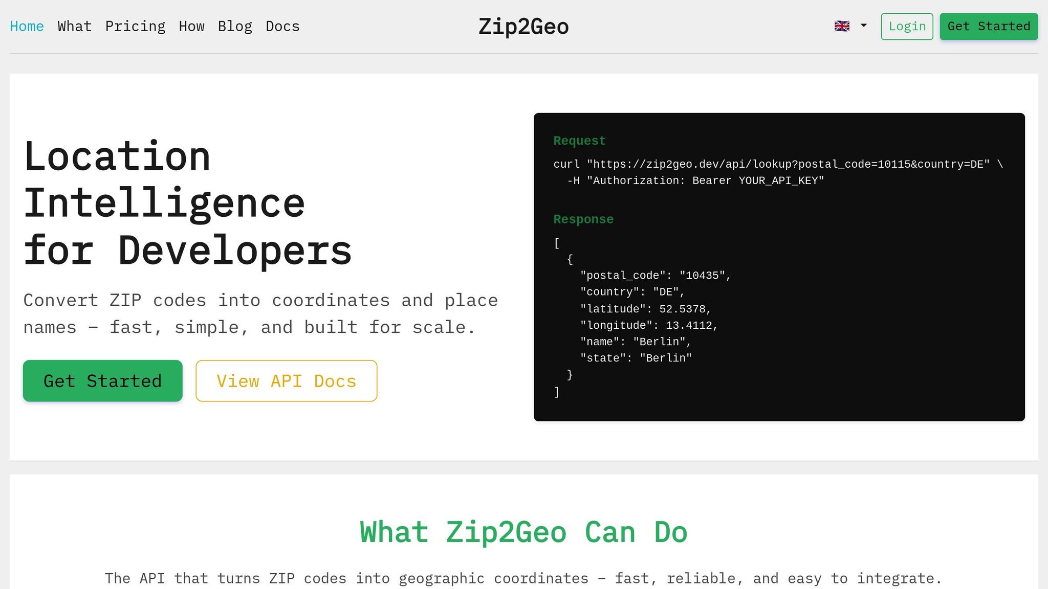
Zip2Geo connects ZIP codes to precise geographic coordinates and key location details through a RESTful API. Supporting over 100 countries, it uses ISO-compliant data structures and constantly updated databases from official postal registries. The API offers advanced features like radius searches to find ZIP codes within a specific distance, distance calculations between locations, and reverse geocoding to map ZIP codes to place names[21,22]. Its v2 architecture ensures fast, stable JSON responses, even under heavy usage, with response times measured in milliseconds. These capabilities are paired with flexible pricing options to cater to various developer needs.
Pricing Plans
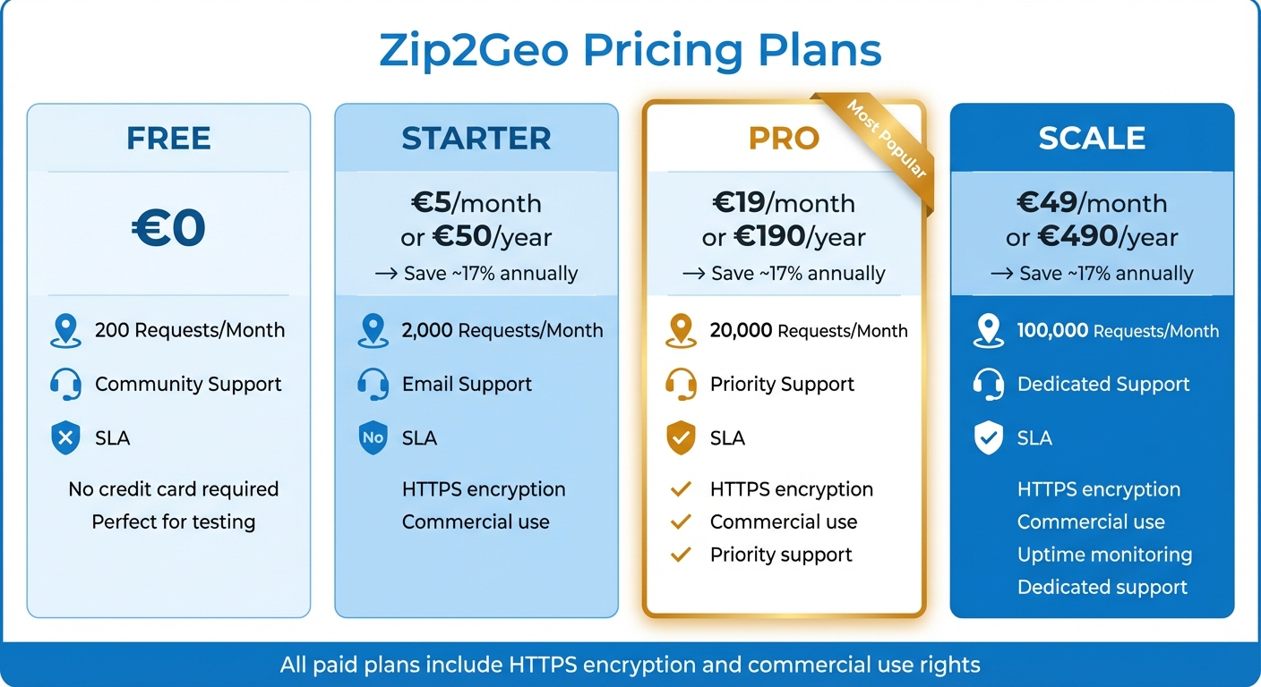
Zip2Geo offers four pricing tiers to accommodate different usage levels. The Free plan is perfect for testing and small personal projects, providing 200 requests per month without requiring a credit card. For €5,00 per month (or €50,00 annually), the Starter plan includes 2.000 requests and email support. The Pro plan, at €19,00 per month (or €190,00 annually), delivers 20.000 requests, priority support, and an SLA. For larger-scale applications, the Scale plan provides 100.000 requests per month at €49,00 per month (or €490,00 annually), along with uptime monitoring and dedicated support. All paid plans include HTTPS encryption, commercial use rights, and access to all endpoints. Developers handling frequent location updates should also consider concurrent request limits when selecting a plan.
| Plan | Price | Requests/Month | Support | SLA |
|---|---|---|---|---|
| Free | Free | 200 | Community | No |
| Starter | €5,00/mo or €50,00/year | 2.000 | No | |
| Pro | €19,00/mo or €190,00/year | 20.000 | Priority | Yes |
| Scale | €49,00/mo or €490,00/year | 100.000 | Dedicated | Yes |
Easy Integration for Developers
Zip2Geo is built with developers in mind, offering both precision and simplicity. Its RESTful design features intuitive endpoints that return consistent JSON responses. Comprehensive documentation covers everything from ZIP code lookups to radius searches and distance calculations, making integration straightforward. The uniform structure of the v2 architecture reduces complexity, ensuring quick setup for real-time queries or bulk processing. This approach not only speeds up debugging but also shortens overall integration time, making Zip2Geo a practical choice for developers.
How to Integrate Geocoding APIs Effectively
Ensuring speed and reliability is just the beginning when working with geocoding APIs. To maintain high performance and avoid issues like security breaches, unexpected costs, or service interruptions, integration practices must prioritize secure credentials, optimized performance, and continuous monitoring. These steps are especially critical for handling real-time, high-frequency updates at scale.
Managing API Keys Securely
One golden rule: never embed API keys in client-side code. Instead, route requests through a backend to keep your keys protected. To further minimize risks, restrict key usage by IP address or HTTP referrer. For instance, the Google Maps Platform lets developers create up to 300 API keys per project - perfect for isolating environments or managing team access effectively.
Store your keys securely, such as in environment variables or a dedicated secrets management tool. Rotate them regularly, and set usage quotas to prevent unexpected costs. Once your keys are secured, focus on reducing unnecessary API calls by adopting caching strategies.
Caching and Rate Limiting
Caching is your best friend when it comes to cutting down redundant API calls. As OpenCage wisely notes:
"The fastest request is the one you don't make".
Some providers allow permanent storage of results, but others, like Google Maps Platform, limit caching of latitude and longitude pairs to just 30 days. However, Place IDs often bypass these restrictions and can be stored indefinitely, making them a cost-effective solution for uniquely identifying locations.
To avoid exceeding rate limits, queue your requests and control their pace. If you encounter errors like OVER_QUERY_LIMIT or server-side issues (5xx), use exponential backoff to retry requests without overwhelming the API. For scheduled jobs, adding random delays can help prevent synchronized spikes in traffic. Batch endpoints are another great option - they often come with discounts of up to 50% compared to individual calls.
Monitoring and Error Handling
Real-time monitoring is essential. Keep an eye on HTTP response headers like X-RateLimit-Limit and X-RateLimit-Remaining to track your API usage. Different response codes call for different actions. For example:
- A 402 (Quota Exceeded) means you may need to upgrade your plan or wait for quotas to reset.
- A 400 (Invalid Request) signals a malformed query that shouldn't be retried.
For temporary errors, exponential backoff can improve success rates while avoiding unnecessary strain on the API.
Rely on client libraries that include built-in retry logic and authentication features. OpenCage, for instance, reported an impressive 99.999% uptime for 2025, but it's still wise to monitor third-party services and check public status pages for updates. Restricting API keys by IP address or application adds another layer of protection, preventing unauthorized use and safeguarding your quotas.
Conclusion
Geocoding APIs play a critical role in powering applications that rely on location data. From managing delivery systems to detecting fraud or enabling real-time tracking, converting addresses into precise coordinates at scale is a key factor in ensuring systems run smoothly. Accurate geocoding is essential to avoid disruptions that can impact both user satisfaction and business operations.
Achieving success in this area requires striking the right balance between precision, speed, and cost. For instance, high precision might be non-negotiable in some scenarios, while broader centroids could suffice in others. Techniques like caching to minimize redundant calls, parallel processing to handle batch jobs efficiently, and exponential backoff to manage peak traffic are all crucial for maintaining performance. Top providers in the industry boast impressive uptimes nearing 99.999%, highlighting the importance of treating geocoding as a vital system component rather than just an optional feature.
This is where solutions like Zip2Geo come into play. Designed with these principles in mind, Zip2Geo offers a fast and straightforward geocoding API that balances cost and performance. With pricing options ranging from a free tier to enterprise-level plans, it provides transparent billing without the confusion of per-request charges. Its robust service-level agreements (SLAs) ensure reliability, making it a dependable choice for production environments.
To build a resilient geocoding system, follow the integration strategies outlined in this guide: safeguard your API keys, use caching to optimize performance, monitor rate limits, and implement error-handling mechanisms. By adopting these practices, developers can ensure their applications are supported by a scalable and efficient geocoding solution, ready to meet the demands of modern, data-driven systems.
FAQs
When do I need rooftop accuracy vs a centroid?
Rooftop-level accuracy is crucial when pinpointing exact locations is a must - think delivery routes or applications tied to specific properties. On the other hand, a centroid works well for broader needs, like analyzing data at a city or regional level. The choice depends entirely on how precise your application needs to be.
How can I handle global postal codes without breaking data?
To manage postal codes from around the world, it's crucial to validate them according to each country's specific format. Since postal code structures differ globally, using regex patterns tailored to individual countries is essential. Pair this with a dependable global postal code database for better accuracy.
For an even more reliable solution, consider using APIs with international coverage. These tools not only ensure precise geocoding but also help reduce inconsistencies in your data. By following this method, you can maintain the integrity of your data while navigating the complexities of diverse postal code systems.
What’s the best way to reduce geocoding latency and costs at scale?
To cut down on geocoding delays and expenses, consider these practical approaches:
- Parallel Requests: Send multiple geocoding requests simultaneously to speed up processing time.
- Caching Results: Store frequently used geocoding results locally to prevent unnecessary API calls for the same data.
- Batch Processing: Group multiple geocoding tasks into a single request where possible, reducing overhead and improving workflow efficiency.
- Structured Data Input: Use well-organized and clean data to streamline the geocoding process, minimizing errors and retries.
These strategies not only save resources but also make large-scale operations smoother and more cost-effective.