Postal codes are vital for travel apps to determine precise locations, calculate distances, and provide users with tailored experiences. However, integrating global postal codes is complex due to varying formats, regional inconsistencies, and evolving postal systems. A reliable geocoding API, like Zip2Geo, simplifies this by converting postal codes into standardized geographic data (e.g., latitude, longitude, city) across 100+ countries.
Key Points:
- Format Diversity: Countries like Germany use numeric codes (e.g., "10115"), while others like the UK and Canada use alphanumeric formats (e.g., "SW1A 1AA", "K1A 0B1").
- Accuracy Challenges: Postal codes often represent delivery points, not precise locations, leading to discrepancies in rural and urban areas.
- Localization Needs: Apps must adapt to regional preferences, such as Germany's address formats, metric units, and date conventions (e.g., DD.MM.YYYY).
- API Advantage: Tools like Zip2Geo streamline geocoding with fast, GDPR-compliant services, offering features like radius searches, distance calculations, and autocomplete functionality.
Quick Overview:
Zip2Geo enables travel apps to:
- Find nearby attractions or hotels using postal codes.
- Plan routes with accurate geolocation.
- Verify user locations and apply location-based pricing.
This integration ensures smoother travel experiences while reducing development complexity for apps targeting global markets.
How to Use Google Maps API in Python | Geocoding, Reverse Geocoding, and Calculating Distance
sbb-itb-823d7e3
Challenges of Using Global Postal Codes in Travel Apps
Global Postal Code Formats and Validation Complexity by Country
Understanding the hurdles of integrating global postal codes into travel apps is critical for developers aiming to build efficient and user-friendly platforms.
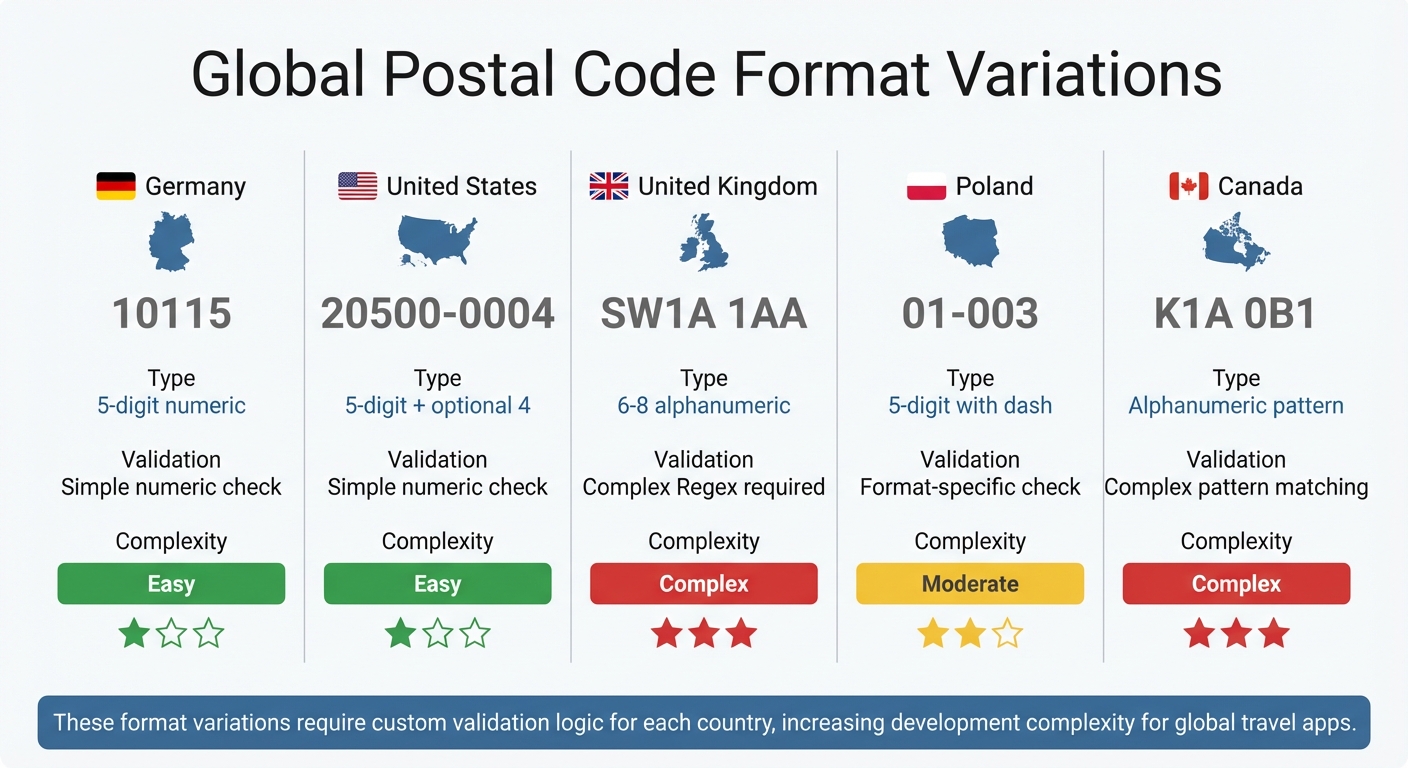
Different Postal Code Formats by Country
Postal codes differ wildly from one country to another. Take Germany, for instance - its PLZ system uses simple 5-digit numbers like "10115". The United States, on the other hand, employs a 5-digit ZIP code with an optional 4-digit extension, such as "20500-0004". Meanwhile, the United Kingdom uses alphanumeric postcodes, typically 6 to 8 characters long, split into "outward" and "inward" segments (e.g., "SW1A 1AA"). Poland requires a dash in its format ("01-003"), and Canada mixes letters and numbers in patterns like "K1A 0B1".
These variations make validation a tricky task. Developers often need custom logic for each country's format, and even then, regular expressions can become unwieldy. They might fail to account for regional exceptions or keep pace with changes. As Ulduz Ismayilova from GeoPostcodes points out:
Incorrect or improperly formatted postal codes can lead to delays, undelivered goods, or lost business opportunities.
Some countries, like Iran and Ghana, use postal codes as long as 10 characters, which only increases the risk of formatting errors.
| Country | Format Example | Type | Validation Complexity |
|---|---|---|---|
| Germany | 10115 | 5-digit numeric | Simple numeric check |
| United States | 20500-0004 | 5-digit + optional 4 | Simple numeric check |
| United Kingdom | SW1A 1AA | 6–8 alphanumeric | Complex Regex required |
| Poland | 01-003 | 5-digit with dash | Format-specific check |
These diverse formats not only complicate validation but also affect the accuracy of location data.
Data Accuracy and Regional Coverage Issues
Postal codes were never designed for pinpoint geolocation. As OpenCage Data explains:
The key point to understand is that postal codes are a tool used by postal services to speed up the delivery of physical mail... this has lead to a mistaken, albeit understandable, perception that postcodes always correspond to locations.
In reality, many postal codes represent delivery points, not geographic areas. For instance, military bases, government offices, or even specific skyscrapers in Manhattan can have unique codes that don’t align with standard spatial boundaries.
The situation gets even murkier in rural areas, where a single postal code might cover vast regions, compared to urban areas where codes can pinpoint individual buildings. In Germany, about 0.1% of address-point postcodes don’t match their assigned postal area, while in France, this figure is closer to 0.7%. Globally, OpenStreetMap records around 84 million postcode tags, with roughly 0.14% of them being incorrectly formatted. Australia’s postcode "0872" even spans multiple states and time zones, adding another layer of complexity.
Localization Requirements for Different Markets
Travel apps also need to cater to regional preferences and standards. In Germany, for example, addresses typically include the street, house number, PLZ, town, and any local subdivisions. German users also expect metric units, 24-hour time formats (e.g., 14:30), and dates written as DD.MM.YYYY.
Postal systems are constantly evolving, with around 44,000 postal codes updated globally each week - new codes are introduced, old ones are retired, and boundaries are adjusted. Without frequent updates (preferably weekly or monthly), travel apps risk directing users to outdated or invalid locations. Furthermore, numeric postal codes are not globally unique. A query for "12345" without specifying a country could refer to a German PLZ or a US ZIP code, leaving geocoders unable to provide accurate results.
How to Integrate the Zip2Geo API for Postal Code Geocoding
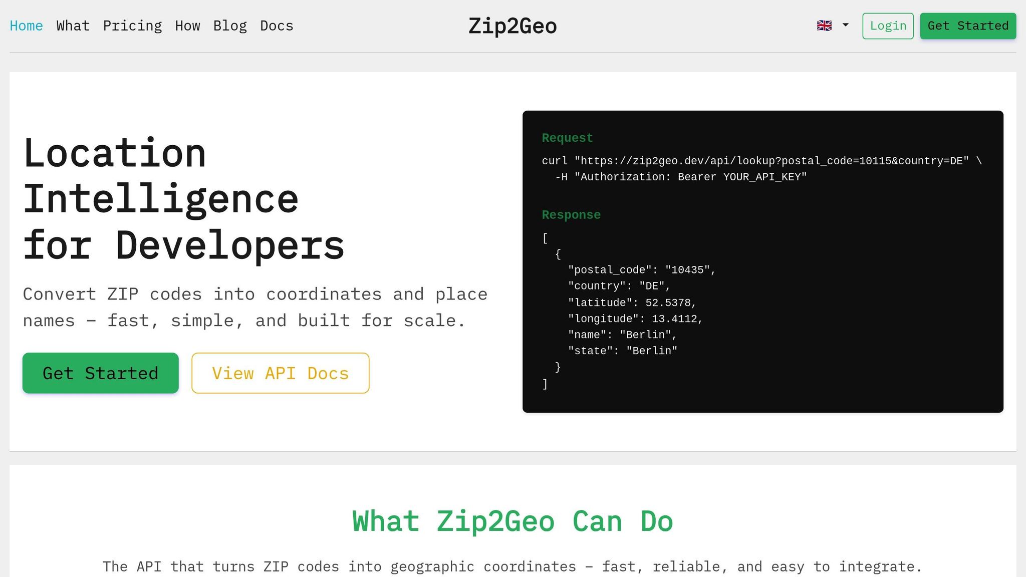
If you're navigating the complexities of global postal codes, finding a reliable geocoding tool is essential. Zip2Geo provides a simple and efficient way to convert postal codes into geographic coordinates and place names across more than 100 countries. Here's a closer look at its features, how to integrate it, and the advantages it offers for travel apps.
API Features and Endpoints
Zip2Geo is built on a RESTful architecture, making it easy to work with through standard HTTP GET requests. Responses are delivered in JSON format, which integrates seamlessly with most modern app frameworks. The API uses two-letter country codes based on ISO 3166-1 Alpha-2 standards, such as "DE" for Germany or "US" for the United States.
The API includes several endpoints for different geocoding needs:
| Endpoint | Purpose | Required Parameters |
|---|---|---|
/v2/info/zip |
Converts a postal code into latitude, longitude, and place name |
countryCode, postalCode
|
/v2/radius/zip |
Finds locations within a specified radius of a postal code |
countryCode, postalCode, distance
|
/v2/distance/zip |
Calculates the distance between two postal codes |
countryCode[from/to], postalCode[from/to]
|
/v2/codes/search |
Searches for location details based on a text query |
query (min 3 characters) |
The API is designed for speed, with response times measured in milliseconds - perfect for travel apps that need to respond instantly to user input. Developers can use the fields parameter for field filtering, requesting only the necessary data like latitude, longitude, or placeName. This reduces payload sizes and improves loading times.
Integration Steps
Integrating Zip2Geo is straightforward, with flexible plans to accommodate everything from small-scale testing to high-traffic operations.
To begin, simply pass the country code and postal code as parameters in a request. For instance, querying the German postal code "10115" will return JSON data that includes latitude (52.5311), longitude (13.3849), city (Berlin), state (Berlin), and country (Germany).
The API documentation includes interactive demos to validate postal code formats for different regions, ensuring smooth integration. Its structured JSON responses make implementation quick and hassle-free.
For travel apps handling heavy traffic, the page[limit] parameter can limit the number of records per request, maintaining performance during peak usage. Additionally, the service monitors for HTTP status code 429, which signals that you've exceeded your plan's request limit.
Benefits for Travel Apps
Zip2Geo brings global coverage and real-time geocoding to travel apps, solving common issues like postal code validation and regional discrepancies. The database is continuously updated, ensuring accurate and reliable location data. Importantly, the API complies fully with GDPR, as it only uses public postal registries and doesn't process personal data. For German-speaking users, the support for metric units (kilometres and metres) aligns with local preferences.
Scalability is another key advantage. The Pro plan offers 20,000 requests per month for €19.00 (or €190.00 annually), while the Scale plan provides 100,000 requests per month for €49.00 (or €490.00 annually). Both plans include SLA guarantees and dedicated support. Subscribers also benefit from price protection, ensuring their rates remain unchanged as long as their subscription is active.
For incomplete addresses or live user input, the search endpoints offer autocomplete functionality - both exact matches and prefix-based suggestions. This ensures accurate results, even when users provide partial or ambiguous data. These features help travel apps deliver precise and tailored experiences to their users.
Use Cases for Global Postal Codes in Travel Apps
Finding Nearby Hotels and Attractions
Postal code geocoding has revolutionized how travelers locate hotels, restaurants, and attractions. For instance, entering a postal code like "10115" for Berlin allows the API to convert it into precise coordinates (latitude 52.5311, longitude 13.3849). Travel apps then use these coordinates to center maps and calculate distances to nearby points of interest.
By using component filtering, search results can be narrowed down to specific areas, ensuring users see only relevant options. Even if a postal code is partially entered or contains errors, reverse geocoding can suggest nearby attractions based on the user's GPS location. In addition, the API can provide a unique place identifier (place_id), which apps use to retrieve detailed business information like opening hours, contact details, and user reviews .
To maintain accuracy, postal codes should always be processed as strings, especially in regions like Germany where leading zeros are significant. Beyond discovery, this level of geocoding precision also improves route planning and user verification.
Route Planning and Navigation
Forward geocoding transforms postal codes into coordinates that power travel app routing algorithms. A global database covering 9.3 million postal codes and 15.9 million coordinates across 247 countries ensures precise calculations for distance, travel time, and even CO₂ emissions.
For travelers, radius-based discovery is a game changer. They can search for hotels or services within a specific distance from a starting postal code, with results calculated in kilometres to align with German metric standards. Using highly detailed postal code data - like full alphanumeric codes in the UK or Canada - ensures pinpoint accuracy for "last-mile" navigation, even down to individual buildings .
Detailed postal code information, including IATA and UNLOCODE data, enhances the precision of these calculations, making it easier to plan routes efficiently and sustainably.
User Verification and Location-Based Pricing
Postal code geocoding isn't just about navigation; it also strengthens user verification and enables tailored pricing. Geocoding APIs provide confidence scores to confirm the legitimacy of postal codes. Reverse geocoding adds another layer of security by cross-referencing a user's GPS location with stored profiles, reducing the risk of fraud.
Administrative data retrieved through geocoding (such as state, province, or locality) supports location-specific pricing. For example, a booking platform can automatically apply city-specific tourism taxes in € for Berlin or Munich based on the postal code entered at checkout.
To avoid errors, it's crucial to use component restrictions that limit inputs to relevant postal codes and countries. This prevents issues like routing mistakes caused by overlapping numeric postal codes, such as "12345", which appear in multiple countries . Additionally, cleaning input data of extraneous characters before sending it to the API ensures better geocoding accuracy and reliability.
Best Practices for Integrating Geocoding APIs
Error Handling and API Rate Limits
To integrate a geocoding API effectively, it's important to understand and handle different types of errors. For instance, transient errors like UNKNOWN_ERROR can often be resolved by retrying the request. On the other hand, permanent errors such as INVALID_REQUEST or REQUEST_DENIED typically require immediate adjustments to your code or configuration. When retrying a failed request, use exponential backoff - start with a 100 ms delay, double it with each retry, and add jitter to avoid overwhelming the server with simultaneous retries.
Avoid scheduling API calls at predictable times, like exactly at midnight or on the hour, as these patterns can create traffic surges that may lead to service disruptions. If you encounter OVER_QUERY_LIMIT, examine your system for redundant calls, optimize your architecture, and consider setting daily quotas to control costs.
| Status Code | Meaning | Recommended Action |
|---|---|---|
OK |
Request successful | Process results |
UNKNOWN_ERROR |
Transient server error | Retry with exponential backoff |
OVER_QUERY_LIMIT |
Usage limit exceeded | Reduce calls, add jitter, or increase quota |
ZERO_RESULTS |
No location found | Check address formatting or use Autocomplete |
INVALID_REQUEST |
Missing required parameters | Correct the request (e.g., add missing address) |
REQUEST_DENIED |
Request rejected | Verify API key and billing status |
For smoother integration, use official client libraries (available in Java, Python, Go, and Node.js). These libraries often include built-in retry mechanisms and secure authentication methods. Always send requests over HTTPS to protect sensitive data. Additionally, improve performance by caching geocoding results and fine-tuning both client- and server-side workflows.
Caching and Performance Optimization
Caching is key to improving efficiency. Save frequent postal code queries and use the Place Autocomplete service to handle incomplete or misspelled addresses with minimal delay. When planning routes, use a Place ID instead of an address string. This avoids the need for re-geocoding, cutting down latency significantly.
For real-time user interactions, client-side geocoding is a better option. It processes user-input addresses faster by considering context like language, region, and viewport. Server-side geocoding, however, works best for predefined data sets or as a fallback when client-side methods fail. Always ensure URLs are properly percent-encoded to handle special characters like spaces or non-ASCII symbols, adhering to URI standards. These optimizations enhance usability and deliver a better experience, especially for users in Germany.
Localization for German-Speaking Users
To tailor geocoding for German-speaking users, prioritize language and region settings. Use the language=de parameter to display results in German and the region=de parameter to focus on locations within Germany, ensuring results align with local standards. German-specific characters, such as umlauts (ä, ö, ü) and the Eszett (ß), require proper UTF-8 encoding to avoid errors. For address formatting, follow the German convention: Street Name + House Number, followed by the 5-digit Postal Code and the City/Locality. Also, account for administrative divisions like Federal States (Bundesländer), Districts (Kreise), and Subdivisions (Ortsteile).
Germany's postal system (PLZ) includes 26,266 postal codes, covering 4,723 regions and 13,097 towns. Some areas near the Austrian border share PLZ ranges, which may require special validation in travel or logistics apps. Since Deutsche Post updates postal data quarterly, ensure your geocoding API or datasets reflect these changes to accommodate new developments or municipal adjustments.
Conclusion
Using global postal codes with a geocoding API like Zip2Geo can significantly improve travel app capabilities in German-speaking markets. By converting postal codes into accurate geographic coordinates, the API supports features like radius searches and distance calculations. This means apps can offer highly localized services, such as finding hotels within a 5 km range of a ZIP code or calculating precise travel routes across regions. For developers targeting Germany, Austria, and Switzerland, this method simplifies managing complex address formats while ensuring smooth performance.
Zip2Geo delivers impressive speed, processing 95% of queries in under 15 ms, which ensures near-instant responses for mobile users. It also adheres to GDPR regulations - an essential factor for apps operating in Europe. With coverage spanning over 100 countries and structured JSON responses, developers can seamlessly integrate location services and scale their apps as their user base expands.
Beyond its technical strengths, this geocoding solution boosts user engagement by enabling advanced search filters, precise user verification for dynamic pricing, and clear neighborhood mapping. These features combine to create a more intuitive and reliable user experience.
FAQs
How can I validate postal codes for many countries without managing extensive regex rules?
To handle global postal code validation without juggling extensive regex sets, consider using APIs or databases that specialize in country-specific formats. Tools like Zip2Geo offer precise geodata, including postal code validation, which eliminates the need for manually managing regex patterns. By detecting the country and utilizing these resources, developers can align with local standards while significantly easing the burden of ongoing maintenance.
How accurate is postal-code geocoding in rural areas versus cities?
Postal-code geocoding works better in cities and urban areas because these places have dense, detailed postal code systems. In contrast, rural regions often lack this precision since their postal codes usually cover much larger and less specific areas.
What’s the best way to handle rate limits, caching, and retries with Zip2Geo?
Efficiently managing rate limits starts with keeping an eye on your API usage through response headers. When you encounter 429 errors, implement retries using exponential backoff - this means gradually increasing the wait time between retries to avoid overwhelming the server.
Another smart move? Cache responses for recurring requests. This reduces unnecessary API calls and helps you stay within your quota. Always stick to the rate limits outlined in your plan, and consider using tools like SDKs or creating custom limiters to automate and streamline request handling. These practices help maintain smooth API operations and prevent interruptions.