The great-circle distance is the shortest path between two points on the surface of a sphere, following the arc of a great circle. This concept is widely used in navigation, aviation, and geolocation because it accounts for Earth's curvature. While Earth is an oblate spheroid, simplifying it to a sphere (mean radius: 6,371.2 km) makes calculations easier and sufficiently accurate for most applications, with an error margin of about 0.5%.
Here’s a quick overview of the key methods to calculate great-circle distances:
- Spherical Law of Cosines: Accurate for most scenarios but may face rounding issues with small distances.
- Haversine Formula: More stable for small distances but slightly slower.
- Vector-Based Methods: Handles all distances, including antipodal points, but requires more computation.
Each method balances precision, speed, and computational simplicity. For example, the distance between the White House and the Eiffel Tower is approximately 6,161.6 km using a spherical model, differing by only 0.25% from the more detailed ellipsoidal calculation.
To get coordinates for these calculations, tools like Zip2Geo provide latitude and longitude based on postal codes. This REST API is fast, supports over 100 countries, and integrates seamlessly with modern applications. Pricing starts with a free plan offering 200 requests per month, scaling up for higher usage.
For general navigation, spherical models are efficient and practical. However, for tasks requiring extreme precision, such as surveying, ellipsoidal models are more suitable.
Great Circle Distances, Longitude and Latitude
sbb-itb-823d7e3
Mathematical Formulas for Great-Circle Distance
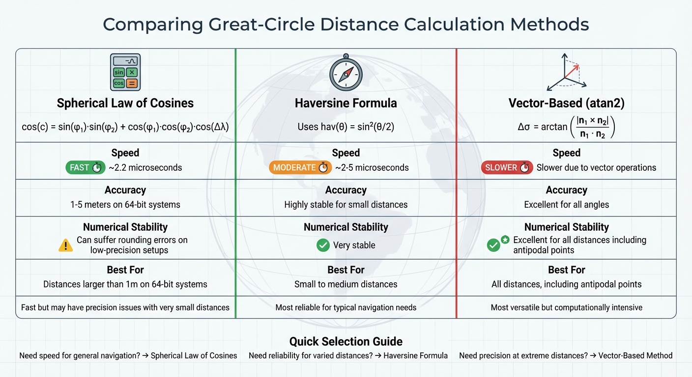
Great-Circle Distance Calculation Methods Comparison
Let’s dive into the formulas that help calculate great-circle distances on a sphere. Depending on the level of precision and computational efficiency you need, there are several methods to choose from.
Spherical Law of Cosines
The Spherical Law of Cosines is a straightforward way to calculate the angular distance between two points on a sphere. The formula is:
cos(c) = sin(φ₁)·sin(φ₂) + cos(φ₁)·cos(φ₂)·cos(Δλ)
Here, φ represents latitude, and λ represents longitude. On modern 64-bit systems (following the IEEE 754 standard), this formula can achieve accuracy within 1–5 metres. However, for very small distances, systems with limited floating-point precision may encounter rounding errors because the cosine of a small angle approaches values like 0.99999999. Despite this limitation, developer Chris Veness noted:
"With this precision [64-bit], the simple spherical law of cosines formula... gives well-conditioned results down to distances as small as around 1 metre".
This method is also impressively fast, taking about 2.2 microseconds per calculation, making it a solid choice for general applications.
Haversine Formula
To address the rounding issues of the Spherical Law of Cosines, especially for very small distances, the Haversine formula comes into play. It uses the function hav(θ) = sin²(θ/2), which helps maintain precision for small angles. Chris Veness explained:
"The haversine formula remains highly stable for small distances - unlike calculations based on the spherical law of cosines".
On modern hardware, Haversine calculations take roughly 2 to 5 microseconds, enabling hundreds of thousands of computations per second. While this formula is highly reliable, it can experience minor rounding errors at antipodal points (locations directly opposite each other on the globe). Fortunately, such cases are rare in practical scenarios.
Vector-Based Methods
Vector-based approaches represent geographical positions as three-dimensional Cartesian vectors instead of latitude and longitude. Using these vectors, the central angle between two points is calculated with both dot and cross products. The formula is:
Δσ = arctan(|n₁ × n₂| / (n₁ · n₂))
Here, n₁ and n₂ are normalized position vectors for the two points. According to Wikipedia:
"The expression based on arctan [vector version] is the only one that is well-conditioned for all angles".
This method is particularly effective for handling antipodal points and ensures stability for both short and long distances. It’s also useful for more complex geometric problems, such as finding the intersection of two paths, where vector algebra can simplify calculations compared to spherical trigonometry.
Method Comparison Table
| Method | Best For | Numerical Stability | Speed |
|---|---|---|---|
| Spherical Law of Cosines | Distances larger than 1 m on 64-bit systems | Can suffer from rounding errors on low-precision setups | Fast (~2.2 μs) |
| Haversine Formula | Small to medium distances | Very stable | Moderate (≈2–5 μs) |
| Vector-Based (atan2) | All distances, including antipodal points | Excellent for all angles | Slower (due to additional vector operations) |
These methods serve as the backbone for many practical distance computations, including those used by geocoding APIs like Zip2Geo.
Using Zip2Geo for Geocoding
Before diving into the mathematical formulas for distance calculations, you’ll need precise geographic coordinates. That’s where Zip2Geo steps in - it converts postal codes into the latitude and longitude values essential for great-circle distance computations.
Core Features of Zip2Geo
Zip2Geo is a RESTful API tailored for developers who need to turn postal codes into accurate geographic data. Covering over 100 countries, it delivers results in JSON format, making integration with modern application stacks smooth and efficient. Each API call provides latitude and longitude in decimal degrees, along with additional details like city, state, and country. The coordinates typically represent the geographic center of a postal code area, making them a reliable base for distance calculations.
Retrieving Latitude and Longitude with Zip2Geo
Using Zip2Geo is simple: you send a postal code to its endpoint, and the API responds with the corresponding coordinates in decimal degrees. These values can then be plugged into spherical trigonometric formulas like the Haversine formula or the Spherical Law of Cosines. Since most programming languages require radian inputs for trigonometric calculations, you’ll need to convert the degrees using the formula:
rad = deg · π/180.
For applications handling large datasets, parsing and caching the JSON output can significantly reduce API calls, boosting efficiency during batch processing.
Benefits for Developers
Zip2Geo is built for speed, with response times measured in milliseconds. This makes it ideal for both real-time applications and batch processing. The service offers flexible pricing plans:
- A free tier with 200 requests per month.
- A Scale plan at 49 € per month (or 490 € annually) for up to 100,000 monthly requests.
Higher-tier plans include service level agreements (SLAs) and dedicated support, ensuring reliability for production environments. With clear documentation and a developer-first approach, Zip2Geo allows you to focus on implementing distance calculations without worrying about the complexities of data conversion.
How to Calculate Great-Circle Distance
To calculate the great-circle distance, follow these three steps carefully:
Convert Locations to Coordinates
Start by obtaining the latitude and longitude for both locations. You can do this by sending the postal code to an API endpoint and parsing the JSON response. For example, Berlin's latitude and longitude are 52.5200 and 13.4050, respectively, representing the geographic center of its postal code area.
Once you have these coordinates, convert them from degrees to radians. This step is crucial before using them in the distance formula.
With the coordinates now in radians, you're ready to move on to the next step.
Apply the Distance Formula
Use the Haversine formula to calculate the central angle between the two points. Here’s how:
-
First, calculate the differences:
Δφ = φ₂ − φ₁ (difference in latitude)
Δλ = λ₂ − λ₁ (difference in longitude) -
Then, compute the value of a:
a = sin²(Δφ/2) + cos(φ₁) · cos(φ₂) · sin²(Δλ/2) -
Finally, find the angular distance c:
c = 2 · atan2(√a, √(1 − a))
The atan2 function ensures better numerical stability, especially when working with points on opposite sides of the globe.
Calculate the Final Distance
To get the actual distance, multiply the angular distance c (in radians) by Earth's mean radius. Use R = 6,371.2 km for metric results or R = 3,956 miles for imperial measurements. The formula is:
d = R · c
This step converts the angular measurement into a tangible distance. The results are highly accurate, typically within a 0.5% margin of error due to the spherical approximation model used.
Limitations of Spherical Models
Accuracy Compared to Ellipsoidal Models
Spherical models simplify Earth's shape to a perfect sphere, which introduces an error margin of about 0.5%. This discrepancy arises because Earth's radius isn't uniform - it ranges from 6,356.752 km at the poles to 6,378.137 km at the equator.
Ellipsoidal models, like Vincenty's formulae, take Earth's oblate spheroid shape into account, achieving much greater accuracy - often within 0.5 mm. For example, the radius of curvature for a north-south line is approximately 1% larger at the poles (around 6,399.594 km) than at the equator (about 6,335.439 km). While such differences might not matter for everyday tasks, they are crucial for applications like professional surveying or defining legal boundaries.
These limitations highlight the importance of choosing the right model for precise distance calculations, especially in scenarios where standard formulas may struggle.
Handling Antipodal Points
Calculating distances between nearly antipodal points - those located on opposite sides of the Earth - can be particularly tricky. Unlike most point pairs, which lie on a single great circle, antipodal points are situated on an infinite number of great circles. This characteristic causes numerical instability in formulas like the Haversine, where values approach 1 and lead to floating-point errors.
"The iteration scheme for the inverse problem is unstable for points which are nearly anti-podal. Thus the method yields no solution in this case." - Charles Karney, GeographicLib
For nearly antipodal points on an ellipsoid, even a slight offset (e.g., 0.5° in latitude/longitude) can require up to 130 iterations to achieve millimetre-level accuracy. Additionally, azimuth calculations near these points become highly sensitive - a position change of just 0.4 nm can result in a 5.3" azimuth difference.
When to Use Spherical Models
Spherical models work well for general navigation, web mapping, and large-scale visualisations where an error margin of around 1% is acceptable. Their simplicity and computational efficiency make them ideal for real-time applications or scenarios requiring rapid processing of thousands of distance calculations.
However, for tasks requiring sub-metre accuracy - such as surveying, aviation, maritime navigation, or geodesy - ellipsoidal models are more appropriate. For very short distances (under 20 km), planar (Pythagorean) calculations adjusted for latitude are often more efficient. For medium distances (20–500 km), Euclidean approximations of an ellipsoidal Earth can deliver better accuracy (around 0.1%) than spherical models, with less computational demand.
| Model Type | Accuracy | Use Case | Limitation |
|---|---|---|---|
| Spherical | ~0.5% | General navigation, global apps | 22 km maximum error |
| Ellipsoidal (Vincenty) | ~0.5 mm | Geodesy, surveying | Fails at antipodal points |
| Planar (Pythagorean) | High (for <20 km) | Localised mapping | Requires latitude adjustment |
Conclusion
The great-circle distance represents the shortest route between two points on Earth's surface, making it a cornerstone for navigation and mapping. This concept plays a key role in aviation, maritime navigation, and mapping technologies.
For most purposes, spherical models offer a balance of simplicity and speed, while ellipsoidal models are better suited for scenarios where sub-0.5% accuracy is crucial. The choice between these models ultimately depends on the specific requirements of your application.
To make these calculations more practical, tools like Zip2Geo provide the necessary geodata. By converting postal codes into precise latitude and longitude coordinates, Zip2Geo simplifies geolocation tasks, allowing developers to integrate accurate location-based features into their applications without hassle.
FAQs
Which great-circle formula should I use for my app?
The haversine formula is a trusted method for determining great-circle distances on a sphere. It is known for its dependable accuracy and is commonly applied in geospatial calculations for a variety of practical uses.
How accurate is a spherical Earth distance in practice?
Spherical Earth distance calculations work well for most practical purposes, typically showing errors of up to 0.3%. However, the precision can differ slightly based on the method used and the exact distance being measured.
Do I need special handling for near-antipodal points?
When dealing with near-antipodal points - locations almost directly opposite each other on a sphere - special handling is advised. Standard geodetic calculations may lose accuracy or even fail in such scenarios. To tackle this, adjustments or alternative approaches, like Vincenty's method, are commonly employed. These methods are designed to deliver more dependable results for these unique cases.