Geocoding transforms location data, like addresses or postal codes, into geographic coordinates (latitude and longitude). This process is vital for disaster response teams to plan, allocate resources, and navigate efficiently during emergencies.
Here’s why geocoding matters in disaster response:
- Improves Risk Assessment: Converts historical disaster data into precise coordinates to identify high-risk areas.
- Enhances Resource Allocation: Maps disaster zones to determine where help is needed most.
- Optimizes Rescue Routes: Pinpoints usable roads and routes, even in chaotic conditions.
- Supports Real-Time Updates: Tracks disasters dynamically for better decision-making.
- Aids Post-Disaster Analysis: Links disaster impacts to socio-economic and infrastructure data for future planning.
Tools like Zip2Geo provide fast, accurate geocoding via APIs, helping responders act quickly and effectively. For example, during Cyclone Idai in 2019, geocoding optimized medical supply deliveries, ensuring aid reached 20 health sites on time.
Best Practices from GIS Disaster Response Community
sbb-itb-823d7e3
How Geocoding Helps Assess Disaster Risks
Historical disaster records often list locations as plain text, like provinces, districts, or towns. Geocoding takes this text and converts it into precise geographic coordinates - latitude and longitude - and spatial geometries that can be mapped. This transformation is crucial because disaster risks and vulnerabilities are highly localized, and broad country-level statistics can hide the critical subnational differences needed for effective planning. These detailed coordinates form the basis for mapping high-risk areas, which are essential for focused disaster preparedness.
Converting Historical Disaster Data to Map Coordinates
Geocoding historical disaster data involves several technical steps. For instance, records (such as those from EM-DAT) are restructured so each location appears as a unique entry tied to a disaster ID. This process includes cleaning up location names by removing extra qualifiers, standardizing diacritics, and updating ISO codes. Accurate data conversion is vital for emergency teams to identify vulnerable areas and allocate resources where they’re needed most.
Between 1990 and 2023, the Geo-Disasters framework geocoded 9,217 climate-related disasters, identifying 45,121 unique subnational locations. The system uses a multi-step matching process: it starts with direct matching of standardized administrative codes (like GAUL) for the highest accuracy, followed by API queries to external geographic databases for text-based names, and finally employs fuzzy matching algorithms for locations with spelling variations.
This approach achieved top-level accuracy for 86% of the 45,121 locations through direct administrative ID matching. For example, during Hurricane Irma in September 2017, name-based geocoding initially mislocated Florida’s landfall to areas in California and Wisconsin due to shared place names. However, by using GAUL identification codes, the framework correctly confined the disaster’s footprint to Florida, aligning with validation data from the U.S. Geological Survey.
Identifying High-Risk Zones on Maps
Once disaster data is geocoded, it can be mapped to reveal spatial patterns that enhance risk assessment. Geocoded records link disaster impacts to hazard intensity, population density, and infrastructure vulnerability datasets.
Take the U.S. tornado outbreak in May 2003 as an example. By using geocoding APIs, analysts mapped the event across 172 counties in 18 states - the widest disaster footprint recorded in the EM-DAT database. This level of detail helps authorities identify which areas are most frequently affected by certain disaster types, enabling them to prioritize resources more effectively.
Geocoding is particularly effective for rapid-onset disasters. In the GDIS dataset covering 1960 to 2018, 92% of floods and 97% of earthquakes were successfully geocoded, compared to just 64% of droughts. Moreover, the proportion of disaster locations assigned to detailed second-order administrative units (like districts or counties) has grown from 19% in the 1960s to 30% since 2010, reflecting improvements in reporting detail over time. These advancements in detailed risk mapping are paving the way for integrating geocoded data into more efficient disaster response systems.
How to Integrate Geocoding APIs into Disaster Response Systems
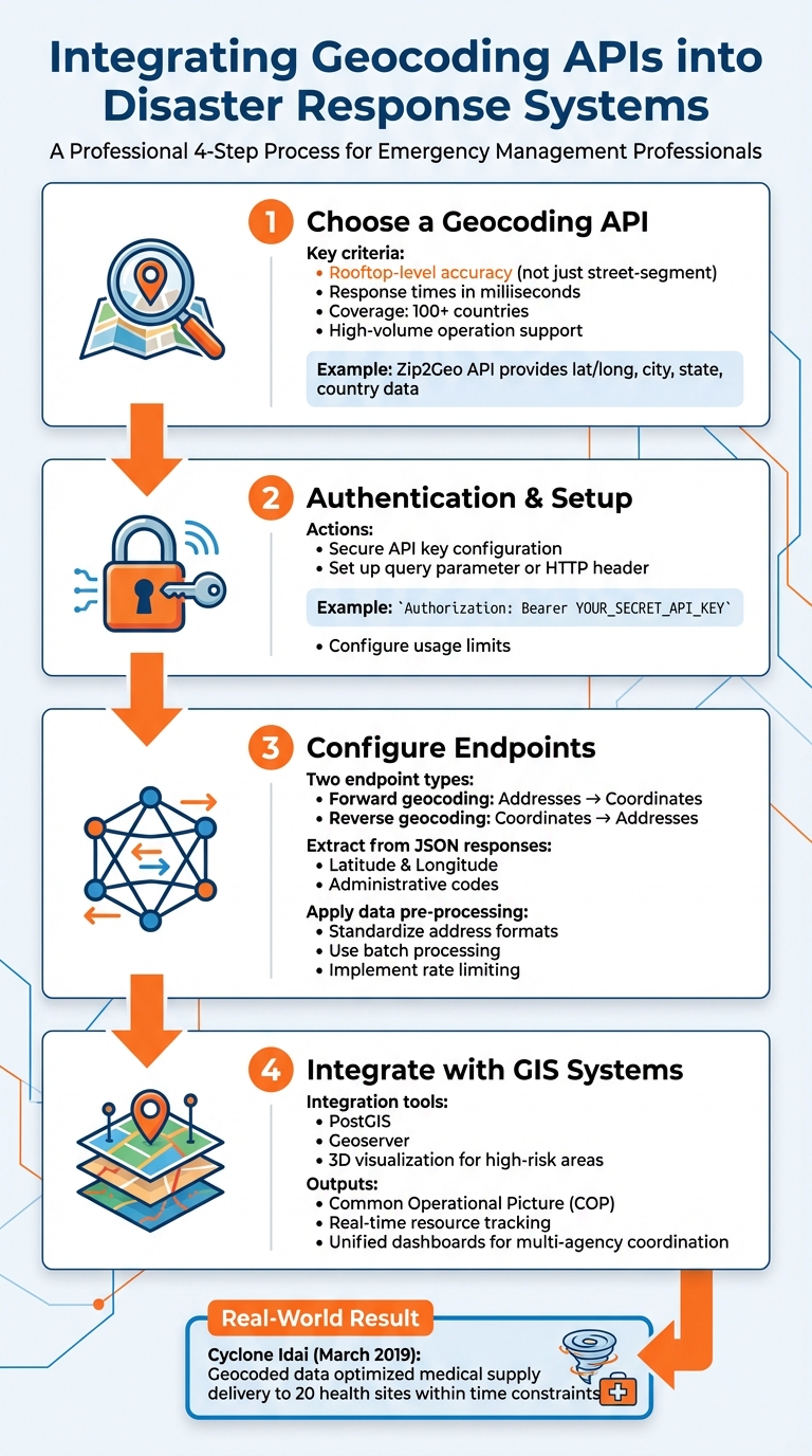
How Geocoding APIs Integrate Into Disaster Response Systems: 4-Step Implementation Guide
Integrating geocoding APIs into disaster response systems requires careful planning and technical setup. This process involves selecting the right API, setting up secure authentication, and connecting the API to your existing emergency management tools.
Choosing a Geocoding API
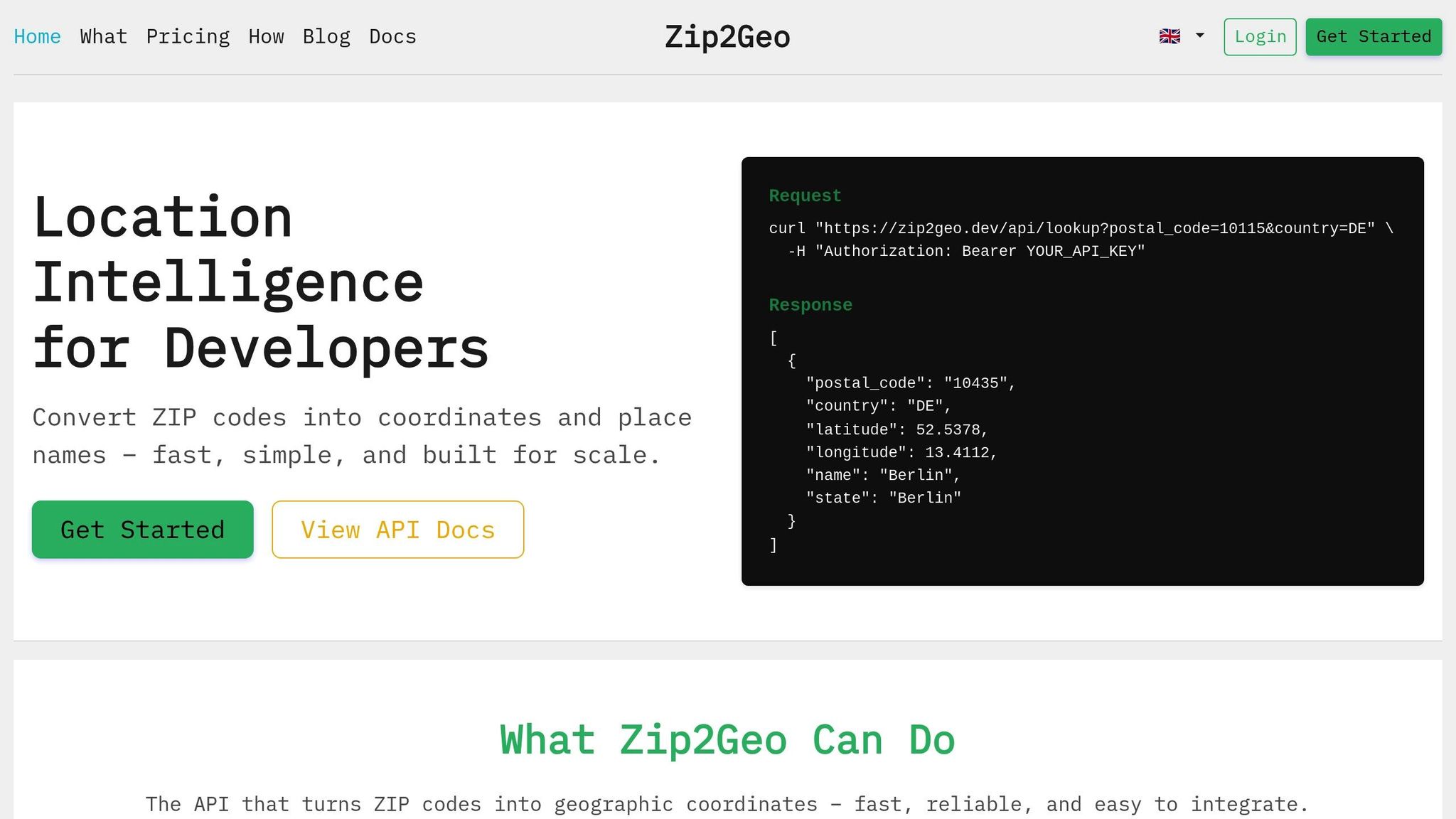
The first step is to identify a geocoding API that aligns with your disaster response requirements. Zip2Geo is a strong option, offering a location intelligence API specifically tailored for converting postal codes into precise geographic coordinates and place names. It provides latitude, longitude, city, state, and country data with coverage spanning over 100 countries, making it suitable for both local and international disaster scenarios.
Zip2Geo’s RESTful JSON endpoints integrate smoothly with emergency management software. Its response times are optimised to milliseconds, enabling real-time data processing during critical situations. Additionally, it supports high-volume operations, making it ideal for handling thousands of addresses or affected households during a crisis.
When evaluating geocoding services, prioritise rooftop-level accuracy over broader approximations like street-segment or postal code centroids. As Berkeley Charlton, Chief Product Manager at Smarty, notes:
Geocoding allows us to know specifically where a property is located on a lot, and whether or not it is susceptible to a natural disaster by giving us more insight into the physical location and its proximity to a disaster.
This level of precision is essential for assessing risks like flood elevation or proximity to wildfire zones. Once you’ve selected the API, you can integrate it into your systems to transform large-scale location data into actionable insights.
Adding the API to Emergency Systems
After choosing your geocoding API, the next step is to incorporate it into your emergency response workflow. Accurate geocoded data is indispensable for mapping high-risk zones, allocating resources, and planning rescue operations.
Start by addressing authentication and setup. Secure your Zip2Geo API key and configure it through a query parameter or an HTTP header (e.g., Authorization: Bearer YOUR_SECRET_API_KEY). This ensures secure access to the service while keeping usage limits under control.
Then, set up endpoint connections for specific tasks. Forward geocoding transforms addresses or postal codes into coordinates, while reverse geocoding converts coordinates back into readable addresses - particularly useful when landmarks or road signs are damaged during disasters . Extract critical fields like latitude, longitude, and administrative codes from the JSON responses to feed into your GIS tools.
Data pre-processing is another critical step to ensure accuracy. Standardising address formats before sending requests improves match rates . Use batch processing and rate limiting to handle large volumes of requests efficiently. For example, during Cyclone Idai in March 2019, humanitarian organisations used geocoded data to optimise delivery routes for medical supplies, successfully reaching 20 health sites within strict time constraints.
Finally, integrate geocoded data into your GIS and workflow systems. Tools like PostGIS or Geoserver can help visualise high-risk areas in 3D, improving situational awareness for emergency teams. Between October 2016 and January 2017, the Slovenian Administration for Civil Protection and Disaster Relief (ACPDR) used a GIS based on the open-source Gaea+ 3D client. This enabled them to automate data collection, manage resources in refugee camps, and establish four new emergency response units in previously inaccessible areas.
Using Geocoded Data to Improve Disaster Response
Geocoding APIs play a crucial role in disaster response by transforming raw coordinates into actionable insights. This integration allows emergency teams to pinpoint locations, chart efficient rescue routes, and share real-time updates across agencies. The result? Faster and more effective disaster relief efforts.
Directing Resources to Affected Areas
Geocoded data enables precise resource allocation through systems like the Common Operational Picture (COP) - a centralised platform where responders can monitor the location and status of resources such as vehicles, equipment, and essential supplies like food and medicine. This level of detail eliminates guesswork, ensuring aid reaches those who need it most.
For example, rooftop-level accuracy identifies specific structures impacted by disasters, saving time and avoiding unnecessary trips to unaffected areas. This precision is particularly valuable during localised events like floods or sinkholes.
Take the case of Cyclone Idai in Beira, Mozambique, in March 2019. Humanitarian teams utilised the openrouteservice optimisation API to distribute medical supplies efficiently. With three vehicles serving 20 health sites, the system accounted for varying needs (ranging from 10 to 148 medication units), vehicle capacities (300 units), and operational hours (08:00–20:00). This approach ensured timely delivery of vaccinations for water-borne diseases while maximising vehicle usage.
Geocoded data doesn’t just streamline resource allocation - it also revolutionises rescue planning.
Planning Faster Rescue Routes
Geocoding addresses the Vehicle Routing Problem (VRP) by optimising fleet operations based on capacity and time constraints. By visualising road access times, responders can identify underserved areas and improve coverage.
Between 2015 and 2017, the Slovenian Administration for Civil Protection and Disaster Relief (ACPDR) used road access time calculations to enhance emergency preparedness. By identifying road sections with access times exceeding 20 minutes, they established four new emergency response units in previously underserved regions.
In another instance, mountain rescuers from Bergwacht Bayern in Bavaria used an "SMS Locator" tool in late 2016 to save a lost individual. A link sent via SMS allowed the victim's smartphone to transmit precise GPS coordinates back to the dispatch centre. Thanks to this geocoded data, rescuers reached the individual within an hour, significantly reducing search time in challenging terrain.
These advancements also improve coordination among multiple response teams.
Coordinating Multiple Response Teams
Geocoding enhances the coordination of diverse teams by enabling real-time tracking on unified dashboards. When agencies operate from the same spatial reference, collaboration becomes seamless. As the National Research Council explains:
The first questions responders ask when a disaster occurs are, Where is it? Where are the victims? Where are the hazards? Where are the resources? The first request from an incident commander is often for a map, and the need is immediate.
A great example is the Virginia Base Mapping Programme (VBMP), launched in October 2001. By February 2003, it provided GIS data to 134 cities and counties, delivering critical information on transportation systems and private-sector facilities. The programme, which cost approximately €7.7 million, saved an estimated €4.7 million to €7.5 million in operating costs during its first year by streamlining multi-agency disaster responses.
Geofencing and unified dashboards further enhance coordination by monitoring entry into hazardous zones and tracking responder locations in near real time. In situations where traditional identifiers like street signs are destroyed, geocoded coordinates become the only reliable way to locate victims or properties.
Using Geocoding for Monitoring and Post-Disaster Analysis
Geocoding isn't just a tool for immediate disaster response - it continues to prove its worth long after the crisis has passed. From tracking events in real time to conducting post-disaster evaluations, geocoding helps teams understand evolving situations and learn valuable lessons for the future.
Tracking Disasters in Real-Time
During an active disaster, geocoding provides critical, real-time insights that help define the event's scope and pinpoint areas needing urgent attention. By converting raw coordinates into actionable data, this technology becomes a lifeline in chaotic situations.
Mobile devices play a huge role here. Geolocation APIs use data from cell towers and WiFi access points to determine locations, which is vital when GPS signals are blocked by debris or damaged infrastructure - or when devices lack GPS altogether. For instance, after Hurricane Katrina, when landmarks were obliterated, reverse geocoding transformed coordinates into precise addresses, helping repair crews navigate the chaos.
Geocoding also supports dynamic risk assessments as conditions shift. APIs offering live updates on flood zones and base flood elevations allow teams to predict which properties are most at risk as water levels rise. Some systems even tap into crowdsourced data from platforms like Twitter/X, treating users as a network of "distributed sensors" that provide instant spatial data on events like earthquakes.
These real-time insights lay the groundwork for thorough post-disaster evaluations.
Analyzing Disaster Impact After the Event
Geocoded data becomes a powerful tool for post-disaster analysis, uncovering patterns that can strengthen future preparedness. By linking disaster data with external datasets - such as population density, GDP, or infrastructure maps - analysts can identify vulnerabilities that exacerbate the impacts of hazards.
The Geo-Disasters framework is a prime example of this approach. Between 1990 and 2023, it geocoded 9,217 climate-related disaster events, achieving the highest spatial accuracy for approximately 80% of these locations. This level of precision allows researchers to explore connections between socio-economic factors and disaster outcomes, such as how income inequality contributes to flood fatalities.
Spatial accuracy is key here. A four-tier quality flag system rates locations from Level 1 (highly reliable) to Level 4 (less certain fallback data). For reliable risk modeling, low-certainty locations should be excluded to ensure the data foundation is solid.
"Geographically explicit impact data unlock the potential to link disaster observations with external datasets, enabling empirical investigation of all facets of disaster risk." - Khalil Teber, Institute for Earth System Science and Remote Sensing
A real-world example of geocoding's impact comes from Fresno County in September 2020. Following the Creek Fire, the county's Public Works and Planning Department digitized FEMA's paper-based assessment process within 24 hours. This shift enabled the real-time export of 8,500 records on road conditions and infrastructure, speeding up aid delivery and reconstruction planning. It’s a clear demonstration of how geocoded data can streamline disaster response and recovery efforts.
Selecting a Zip2Geo Plan for Your Disaster Response System
When integrating geocoding into a disaster response system, picking the right Zip2Geo plan is crucial for balancing efficiency, cost, and precision. Your choice should align with your system's request volume, processing speed, and accuracy needs. Disaster response systems typically require both batch geocoding for analyzing historical risks and real-time processing to manage active crises effectively. Batch processing, for instance, is approximately 50% cheaper per address (around 0.5 credits) compared to real-time requests.
Precision is key in disaster scenarios. High-accuracy geocoding, such as rooftop-level precision, can significantly improve rescue operations and resource allocation. This is especially critical for predicting the impact of disasters like hurricanes or wildfires on specific properties. In contrast, lower-resolution geocoding might suffice for tasks like vehicle routing. As Berkeley Charlton, Chief Product Manager at Smarty, explains:
Rooftop geocoding can tell individuals where a disaster occurs and accurately predict which properties were affected.
This level of detail is essential, especially considering that more than 5% of mailing addresses are incomplete, creating potential gaps in disaster response efforts.
For systems handling large volumes of requests, plans that support higher request rates and permanent coordinate storage are ideal. These features are particularly useful for post-event recovery and rebuilding, ensuring your system can manage surges and retain vital geodata for analysis.
Zip2Geo Plan Comparison
| Plan | Price | Monthly Requests | Best For | Key Considerations |
|---|---|---|---|---|
| Free | Free | 200 | Testing and small personal projects | Ideal for proof-of-concept development; no credit card needed |
| Starter | €5/mo or €50/year | 2,000 | Live projects and side apps | Includes email support; great for local emergency services with limited scope |
| Pro | €19/mo or €190/year | 20,000 | Growing apps and teams | Offers priority support and SLA guarantee; suitable for regional disaster response |
| Scale | €49/mo or €490/year | 100,000 | High-traffic products & enterprise | Comes with dedicated support and uptime monitoring |
For organisations needing unlimited geocoding, dedicated API servers are available starting at around €700. Using batch API calls for historical data integration can further lower costs by up to 50% without compromising accuracy. Choosing the right plan equips your response team with the tools and capacity needed to act swiftly and effectively during emergencies.
Conclusion
Geocoding has revolutionized the way disaster response teams operate, turning raw data into actionable strategies. By converting addresses into precise geographic coordinates, emergency responders can predict risks, navigate through chaotic terrains, and allocate resources with pinpoint accuracy. In scenarios where road signs are gone and landmarks are unrecognizable - common in major disasters - latitude and longitude become the lifeline for identifying exact locations and reaching those in need. This level of precision not only saves lives but also ensures resources are used efficiently.
The difference between street-level and rooftop-level precision is critical. It can determine whether a structure is located accurately or missed entirely. Such granular detail feeds predictive models, allowing teams to assess risks like a 25% chance of hurricane flooding based on proximity to the coastline - long before a disaster even occurs.
By incorporating a dependable geocoding API like Zip2Geo into disaster response systems, organizations can make faster decisions, coordinate teams more effectively, and streamline recovery efforts. Zip2Geo offers rapid data conversion with response times in milliseconds, starting at just €5 per month, making it a practical option for teams of any size.
As the National Research Council aptly states: "Successful response starts with a map". Geocoding provides that map, transforming raw data into life-saving insights and reducing the impact of disasters.
FAQs
How accurate does geocoding need to be for disaster response?
Geocoding for disaster response demands exceptional accuracy, ideally down to rooftop-level precision. This level of detail is crucial for pinpointing high-risk areas and ensuring smooth coordination during emergencies. With precise geodata, responders can allocate resources more effectively and make well-informed decisions when time is of the essence.
What data should be cleaned before using a geocoding API?
Before submitting address data to a geocoding API, it’s crucial to clean and standardize the information for better accuracy. Look out for issues like missing or misspelled elements, inconsistent formatting, or incomplete details. Make sure street names, cities, postal codes, and states are correctly spelled and follow a consistent format. By tidying up the data beforehand, you help geocoding services handle it more efficiently, minimizing errors caused by unclear or poorly organized input.
How do we use geocoded data for real-time routing and coordination?
Geocoded data plays a crucial role in improving real-time routing and coordination during disaster response. By converting addresses or place names into exact geographic coordinates, it enables accurate location identification - even in situations where traditional address systems might fail or prove unreliable.
Integrating geocoding APIs like Zip2Geo into dispatch systems allows emergency teams to plan routes dynamically, steer clear of hazards, and allocate resources effectively. This not only speeds up response times but also ensures that aid reaches those in need as quickly and efficiently as possible.